Route: Hannaford Road, South West Coast Path (Revelstoke Drive), Passage Road
Approximate distance: 7km
Start / Finish: Noss Mayo Car Park
Highlights: A perfect combination of coast, countryside and chocolate box Devon
What makes Devon? I think top of the list would be the very green undulating countryside, criss-crossed with giant hedgerows. Within this landscape, a tangle of narrow lanes twist through tunnels of leafy greens. Crystal clear rivers bubble off the moors, tinkling down towards the coast and widening into expansive tidal estuaries of mud and sand. Rounded headlands and promontories thrust out high above the sea. Cows and cottages and cream compete with tractors blocking the high streets of jaunty villages and towns. Bunting abounds. There is more than a touch of the idyllic in Devon.
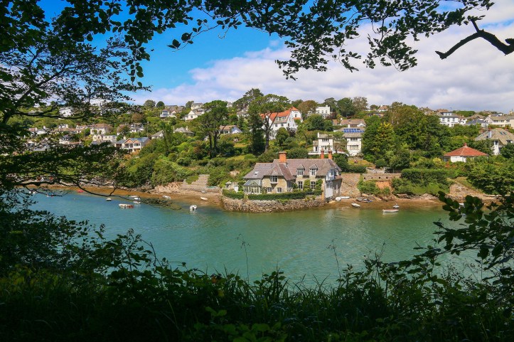
The city of Plymouth may well be another matter. Nonetheless, the Devon of postcards and chocolate box fame is never far away. Passing into the South Hams from the city borders, the villages of Newton Ferrers and Noss Mayo are but a shortish drive. Unless you get stuck behind a tractor. Nestled into hills beside meandering tidal inlets, it is almost as if you have stumbled upon a hidden gem of a paradise. Another world entirely.
Some walks are so good (and pretty convenient) that you keep coming back. Of the many things in favour of this walk are its relative ease, its circular nature, its blend of countryside, coast and cottage, and the capacity for an ale or feed – or both – along the way. It represents the very epitome of all things Devon, perhaps apart from the apparent lack of cream tea.
As a circular you can start this walk anywhere, but the two most accessible places are in the village of Noss Mayo itself, or some National Trust parking up at The Warren which is closer to the coastline. Parking in the village may also be possible at the Ship Inn, though pay heed to warnings of a rising tide. Personally, I prefer starting in the village because you get the uphill climb out of the way early and then have the reward of the pub at the end.
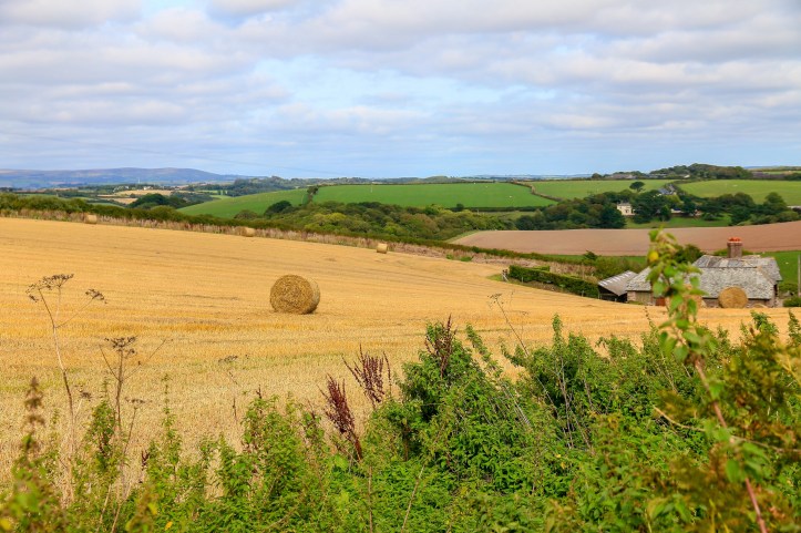
And so, from Noss Mayo’s small car park it begins. Head up an archetypal country lane (listed as Hannaford Road), initially passing a few of the more fortunate council houses in Devon before emerging into open countryside. Depending on the season, expect anything from ploughed brown fields, green pastures dotted with sheep, vivid yellow rapeseed spilling over the horizon, or golden grasses of grain. Passing a cluster of cottages as you continue to climb, views back north into the heart of Devon open up.
After about a kilometre from the car park this lane reaches a more prominent road – still ridiculously narrow and lined with five metre high hedgerows – but at least it’s properly sealed. Climbing for the day is done, and a left turn here quickly brings you to the Warren Car Park, from where the coast is but a short amble away.
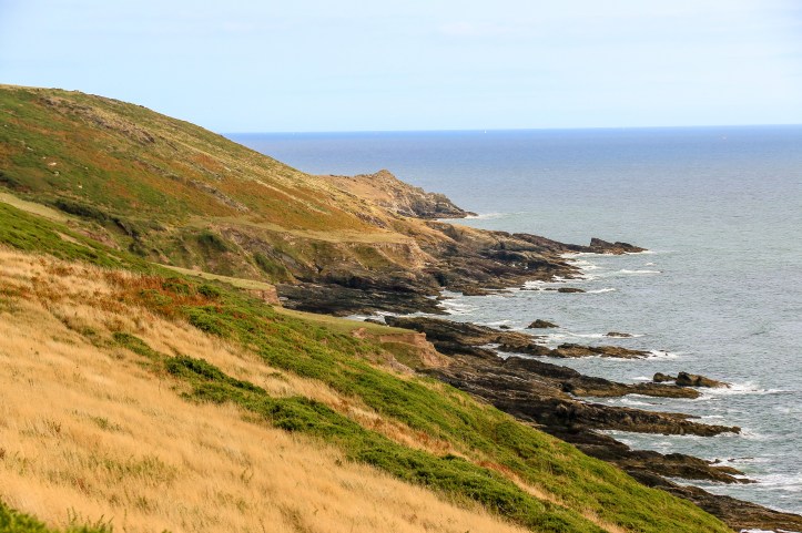
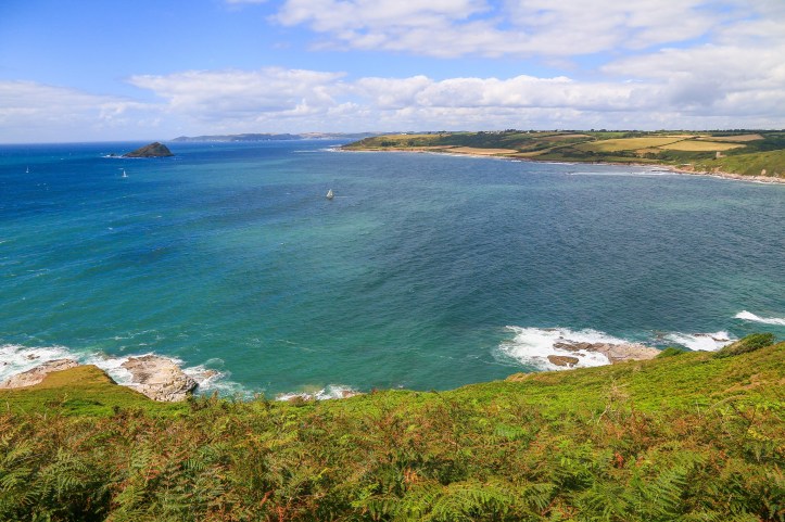
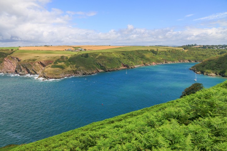
It can be a windswept affair up here, waves thrashing and crashing at the pockmarked border of land and sea. Though lacking the drama of the Atlantic-facing coastline of Southwest England, the views out to the ocean are impressive. On a clear day, the southern coastline of Cornwall stretches out to the west, while south and east the Devon coast rolls and tumbles towards Bolt Head.
Walking is free and easy, following the South West Coast Path westward, as if you were heading towards Plymouth Sound. The path here follows a route known as Revelstoke Drive, which was built as a carriage driveway by some bloke called Lord Revelstoke to show off his property and wealth to other toffs who were visiting. Haw haw haw.
For all its bourgeoise beginnings, today it provides an open and accessible route high up above the sea, trampled by oiks from Plymouth and those from further afield. But unlike some other parts of the South West Coast Path it remains relatively untrammelled, retaining a sense of rugged isolation. Occasional farm animals – cows, sheep and ponies – offer company, the sheep clinging to steep sided hills, seemingly one misstep away from oblivion.
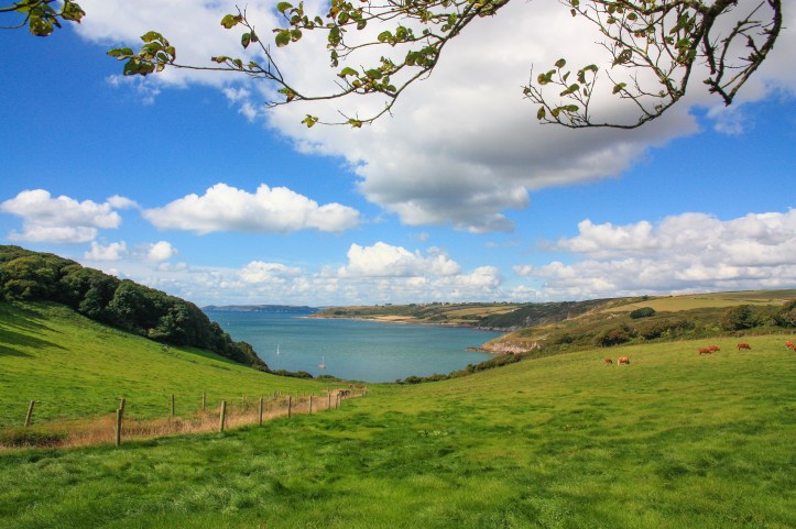
A couple of kilometres from the Warren Car Park the drive begins to turn a corner, mirroring the course of the River Yealm as it begins to work its way into the Devon countryside. The outlook here is one of the best, taking in the Mewstone and Wembury Bay, Rame Head protruding on the other side of Plymouth Sound. To the north, the river estuary funnels into the hills, rich farmland and verdant woodland lining the precipitous banks. Glimpses of cottage and bunting shimmer in the folds, as yachts ply their way towards sanctuary.
From this point, the third stage of the walk commences, leaving the coast and heading into pure chocolate box. Lush fields merge into burgeoning woodland, following the Yealm and Newton Creek as it turns back towards Noss Mayo. Settlement intensifies with a cluster of cosy farmhouses and gracious villas. Over wooden fences and through massive fuchsias, glimpses of snatches of life hinting at a utopia.
From this relative conurbation, a road again forms and heads down towards the water’s edge, where a plethora of boats bob up and down, anchored for an hour, a day, a week, a life. You can follow the sealed lane here, or detour slightly off into Ferry Wood. The latter taking you closer to the water and an old ferry keeper’s cottage before re-joining the lane. Toll signs evoke a life past, when people were employed to collect shillings and farthings for a ride across the river.
Today, a ferry persists further along Passage Road, seasonal for foot traffic linking the South West Coast Path between Noss Mayo and Wembury. A small slipway provides access to the water, from where people can signal the ferry the old-fashioned way: using a coloured board or maybe just giving a good hearty whistle and performing a frantic flailing of arms. If all else fails, technology might be permissible to simply give the boatman a call; but the old-fashioned way seems more apt.
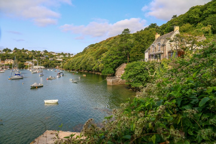
On this occasion, summoning a ferry needn’t be a concern as the walk heads back into the village. The lane heading that way is endearingly pretty, offering outlooks over the creek framed by leaves and branches, the cottages of Newton Ferrers ascending the hill on the other side. At this point the tide may well determine the scale of prettiness: low tide revealing oodles of mud and a possible short cut to Newton.
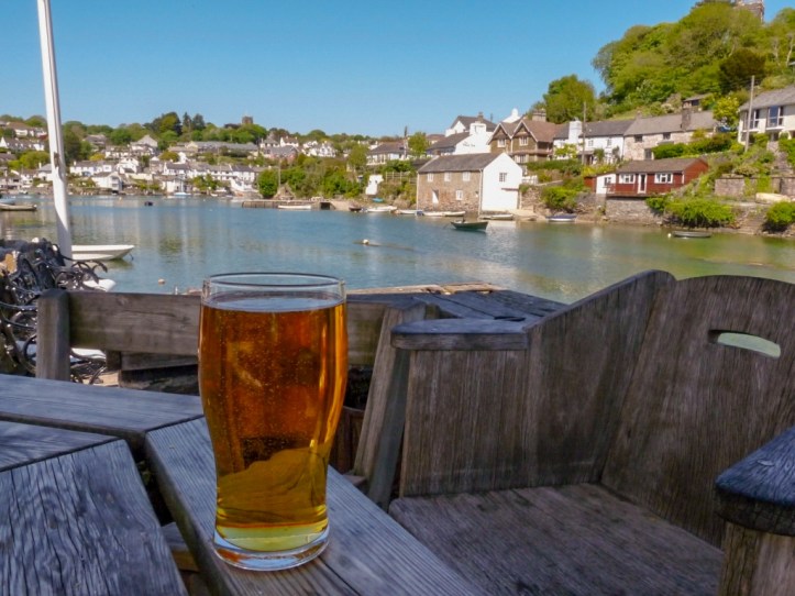
 Don’t take it. Just follow the road past delightful cottages and window box gardens and weigh up the taxing option of a stop in The Ship or The Swan. Both have their merits and both offer a waterside ale. The Ship boasts the better beer garden, though you do tend to pay for it. I seem to remember The Swan offering some better beer choices…but it’s all down to personal preference.
Either way, pause and soak it all in. This very ambience of Devon, passing by without a trouble in the world. Sit and stare and sip and – as half a pint goes quickly to your head – begin to muse what many have mused before: wouldn’t this be the life. Wouldn’t this be a dream.
Extra Steps
- Of course, the fact that this walk links up with the South West Coast Path means that there are numerous extensions or alternative options to explore in the area. You could, for instance, in summer take the ferry over the River Yealm and walk to Wembury (with possible public transport connections at either end linking with Plymouth). And instead of a pint, opt for some tea and cake at the National Trust café on Wembury Beach.
- The alternative direction along the coast leads to Mothecombe, at the mouth of the Erme estuary. Might be a bit much to walk all this in one day, but Mothecombe warrants a visit in itself – when the tide is out there is a great, fairly short circular walk taking in the upper reaches of the estuary and Mothecombe Beach. It’s one of the more undisturbed areas of the coast and the beach is one of the finest along this stretch of Devon coast.
- I have previously done this walk taking a bus from Plymouth. The positives of this are you don’t have to negotiate slightly terrifying narrow two car lanes that can barely fit a single car and you could probably have more than a pint at the pub! The downsides – the bus takes a bit longer and is pretty infrequent (for planning purposes, best to allow 2 hours for this walk).
Links
A guide and map to this walk: https://www.nationaltrail.co.uk/england-coast-path-south-west/route/noss-mayo-and-revelstoke-drive-circular-walk
Visitor information for Noss Mayo: https://www.visitplymouth.co.uk/explore/noss-mayo-p1200623
Noss Mayo – Wembury Ferry: https://www.nationaltrust.org.uk/noss-mayo/features/noss-mayo-ferry
Current bus timetable (as at Jan 2020): http://www.targettravel.co.uk/route/94/
