hundreds
Canberra does not – thank the lord – have anything like a Bournemouth Beach, a place where more than the entire population of Canberra recently decamped for a day of sun, sand, and sputum. Looking from afar, my beloved homeland is looking more of a failed experiment by the day, a reputation only diminished by whatever still consists of that Land of the Free. Yet I see this, I say this, with not an ounce of joy, without any smugness that can come from some in an Australian position. I feel infuriation, despair, and a little guilt at being so lucky so far away.
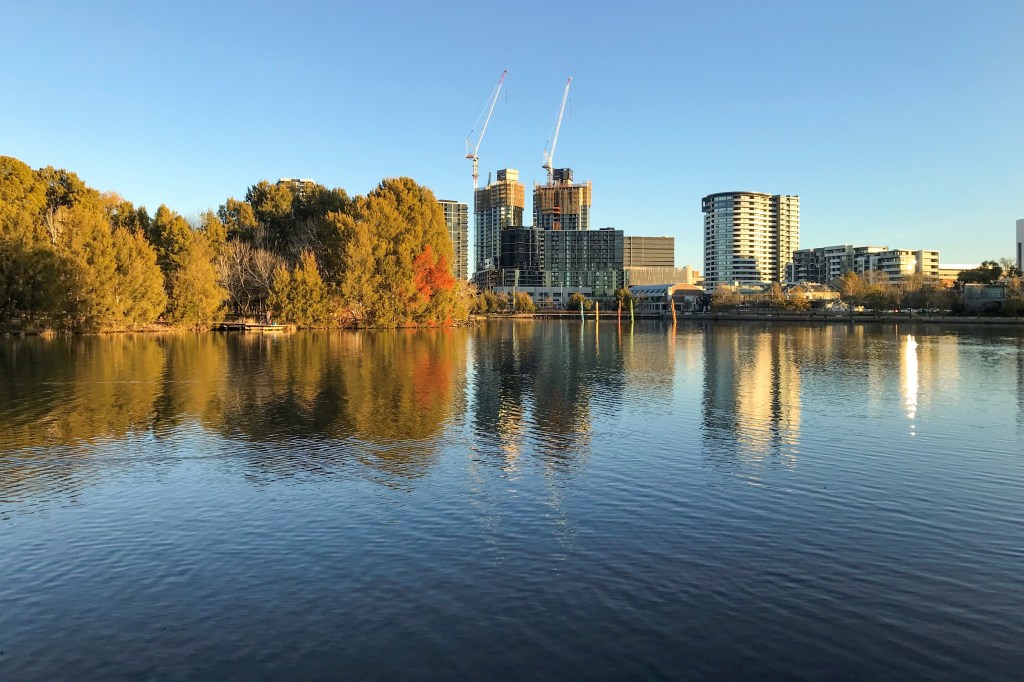
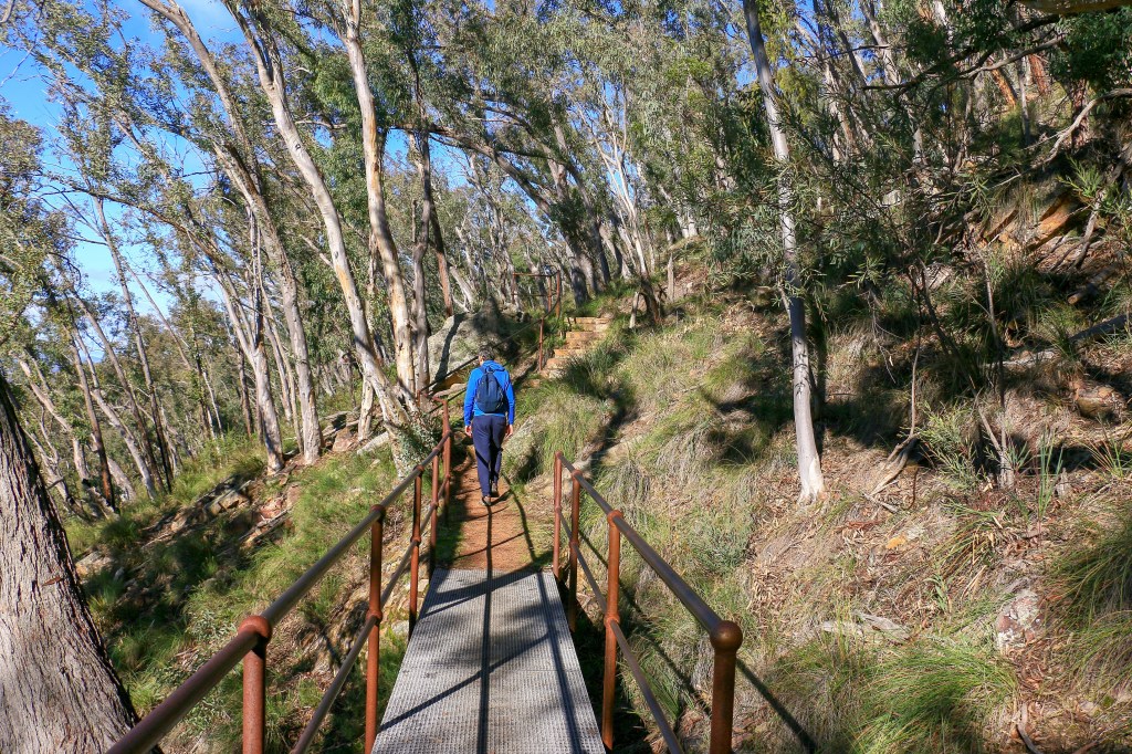
Far from Bournemouth Beach I cast my gaze over the National Arboretum towards Lake Burley Griffin, pooling within the contours and curves of the land. It’s a Sunday around noon, on a beautiful sunny and calm winter’s day. The temperature is only around thirteen degrees but, in the sun trap, it feels like one of those early days of spring when you cautiously remove an overcoat and hang it off your arm. It’s still late June but the sunset is three minutes later than a week ago after all.
The conditions have brought out the crowds. No Bournemouth Beach but as close as Canberra will ever get to it. There must be hundreds and hundreds of people strolling, cycling, playing, picnicking, climbing, hiding, drinking, milling, sitting, watching, and hanging coats off of their arms in that cumbersome way. It’s a bit of an affront to have such hubbub accompanying a walking track in Canberra in winter in the midst of a global pandemic.
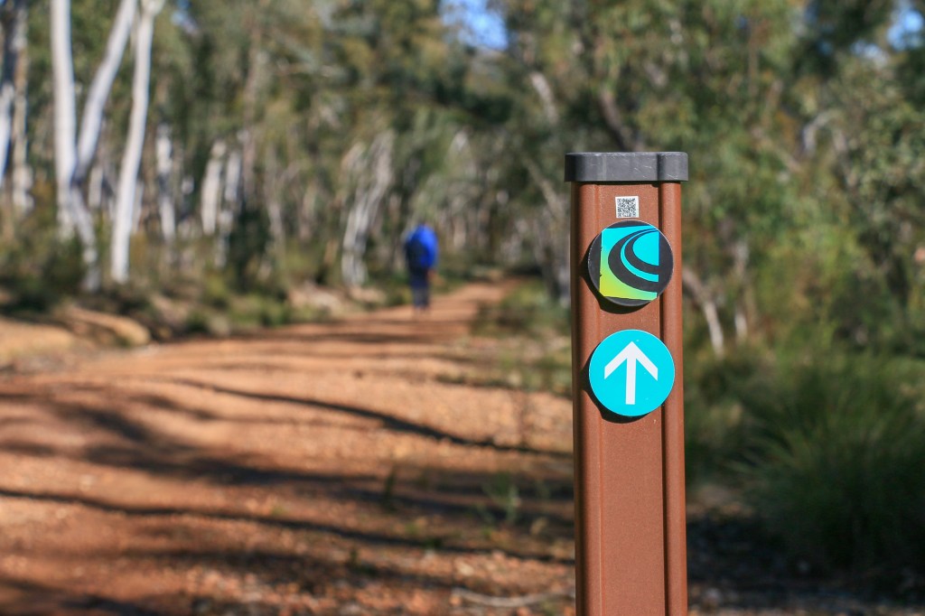
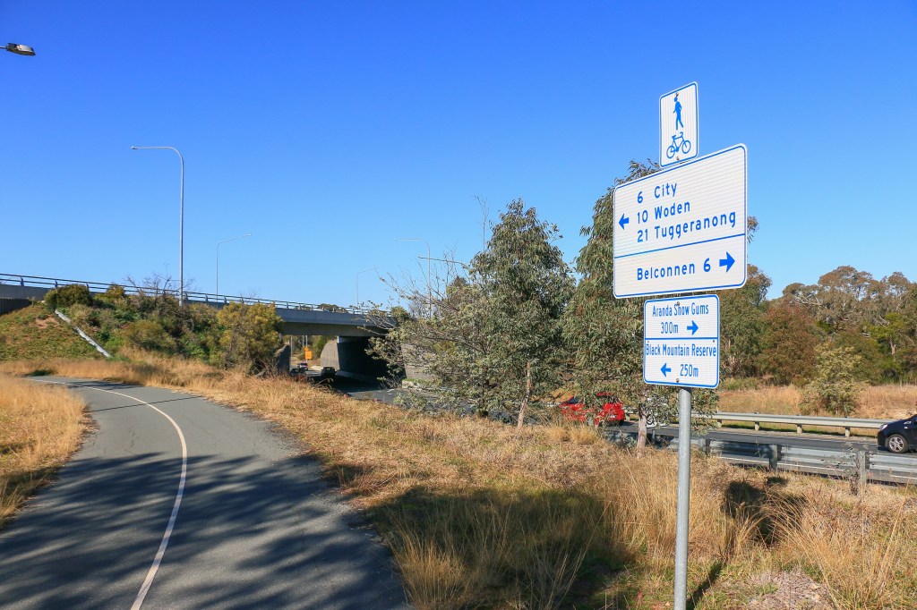
Among this crowd I may be the only one Centenary-Trailing, though this is as hard to decipher as the trail route here. I have now completed – at least according to my unreliable app – over one hundred kilometres. The homeward stretch down the Murrumbidgee now glows in the sun to my right, the towers of Woden rising from the bush with Isaacs Ridge behind. To my left, Black Mountain finally surmounted, and the needle of that tower now destined to be at my back.
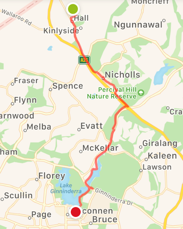
- Day 12: Hall to Belconnen Town Centre
- Day 13: Belconnen Town Centre to Botanic Gardens
- Day 14: Black Mountain and Aranda Bushland
- Day 15: National Arboretum and Rock Collection
Heading south again. Like a Brummie destined for the English Channel. The beaches of Lake Tuggeranong here I come.
Monday June 8: odours

A curious fact about Australia is that we still have a public holiday to celebrate the Queen’s birthday. And while you could lament the sycophantic kowtowing to a head of state many thousands of miles away reeking of colonial subjugation, the simple matter of the fact is that it is not, and is nowhere near, her majesty’s anniversaire. Or should I say geburtstag.
Apparently, Queen Elizabeth II holds the prestigious title of being the UK Royal with most visits to Canberra. Nine times. It’s obviously not a consequence of the longevity of one’s career or – until recently – the increasing ease of international travel; rather, a preference for spending time in Australia’s capital instead of – say – some tacky theme park on the Gold Coast. I was in town for her last visit and I remember seeing images of Liz and Phil gallivanting around the grounds of Government House in a golf buggy pestering the kangaroos. After nine visits still typical Pommie tourists.
Personally, I think a better photo opportunity would have been a royal unveiling of the Crace Odour Control Project, a standout of today’s Queens’s Birthday walk along the Centenary Trail. Picture it: cutting a ceremonial bog roll while pretending not to notice the putrid stench in the air; taking a glass-bottomed boat down a brown waterway to diligently marvel at the effluent vents; and, as per usual, restraining Phil from making inappropriate and offensive comments about anyone and anything. The fawning media would have lapped up all that shit. But no, kangaroos in the grounds of a colonial country mansion.
Unlike an antiquated hereditary dynasty, the Canberra Centenary Trail certainly offers diversity and today’s walk was a day to embrace diversity. After soaking up remote stretches of rolling countryside and forest along the northern border, the next leg presents a stark transition heading towards the glimmering high rises of Belconnen Town Centre. Along the way, flirtations with busy traffic intersections, conglomerations of fast food and gasoline, footsteps along hard-packed cycle lanes, an encounter with dinosaurs and – of course – an innovative odour control project in action. Or inaction.
It wasn’t all crap though, starting and finishing in pleasant surrounds under a golden winter sun. Beginning at Hall, the trail roughly guided one through its quiet streets and past the showground, over a bridge and on towards a few pastoral smallholdings. Hall is very much the archetypal country village for city type, boasting a cluster of historic buildings in between agricultural supplies and crafty shops. The showground is fringed by old sheds and ramshackle wooden fencing, offering a spacious setting for the almost famous monthly markets. No doubt there is also a village hall in Hall.

Hall is a part of the ACT but not really Canberra. It came into being before its bigger sister, a scene that is hard to imagine today. While still detached, the gap between the two appears to be getting squeezed. Testament to this is a fairly new intersection of traffic lights and filter lanes directing people to the Gungahlin and West Belconnen suburbs spilling out into the bush. Straight ahead, across the road, the Centenary Trail meanders on towards Gold Creek.
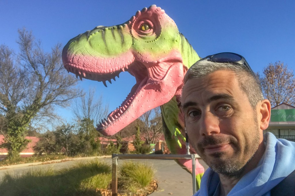
Gold Creek is a funny little place, essentially offering a fun family day out in the one location. There is a dinosaur museum, an aviary, a place for reptiles, and – the piece de resistance – Cockington Green, a model village inspired by the Devonian thatched cottages of West Torbay. Supplementing these attractions are the requisite number of craft shops, cafes, a ‘British Style’ pub, a motel loosely based around Lassiters in Neighbours, a service station and the fun family dining experiences of McDonalds and KFC. Thus it meant that the Centenary Trail now had the salubrious distinction of encompassing two fast food restaurants and a petrol station in the one vista, proving that you really do get a little bit of everything on this walk.

Given the amenities and relative lack of excitement today, stopping for a coffee and piece of cake seemed like the right thing to do, as a treat. Not that I could say there was anything inspiring about the options – it always seems like touristy areas have, at best, mediocre cafes. This one, which was inordinately busy and I’m pretty sure flouting COVID guidelines at the time, offered the temptation of scones, a temptation exacerbated by the other pitiful looking cakes on display. Being the Queen’s Birthday and all that, why not go full scones and jam and cream and lament that this is not the United Kingdom when the cream arrives. At least mediocre cafes in Australia generally serve a decent coffee, unlike one’s mother country.
I was expecting afternoon coffee and cake might prove the highlight of today’s walk, though I didn’t know about the Crace Odour Control Project. Near here, the trail passes the old Blacksmith’s Workshop of Harry Curran, built around 1860 and now fenced off, before getting very close to the Barton Highway. Like gravelly tarmac close. Like out of control double-axle trailer with faulty brakes close. This, coupled with the increasing aroma of something gone awry, leads me to surmise that this is the worst section of the Canberra Centenary Trail to date.
Things perk up a bit as a pavement appears to take you alongside the brown trickle of a concrete drainage channel. Decorated with obliterated tyres and shopping bags, the channel leads to a larger system of pondage and concrete passing underneath another intersection; this one a roundabout that has become so complicated, so congested that it has adopted the British style system of lights and complex lane markings. Happy Queen’s Birthday everyone!
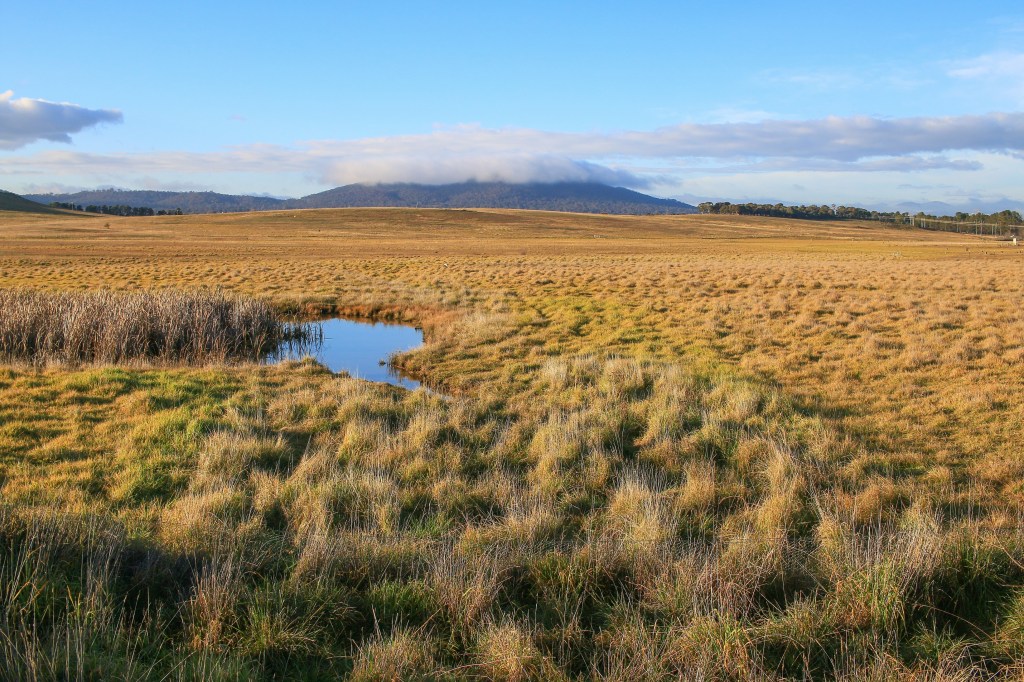
Now turning south towards Belconnen, the trail follows a well-maintained cycle lane mercifully a little away from the road. For now. In fact, views to the west are distinctly pastoral, the rushes and reeds of Ginninderra Creek meandering towards open fields and woodland. Further along, the scene reflects an English winter’s day upon the water meadows and playing fields of a floodplain. Dog walkers and wellies are all the rage, gathering some fresh air before a warming roast dinner.
Australian suburbia re-emerges on another disappointing stretch of the trail next to a busy William Slim Drive. This one at least continues to follow a paved cycle lane but mystifies with other lanes branching off alluringly into parkland, none of which are to be followed. Nope, stay next to the road and enjoy the occasional Canberra roundabout.
I suppose the roundabout is a Canberra highlight, at least for Australians. Residents in other cities tend to favour those awful American-style traffic-light intersections, while in Melbourne these are horrifically embellished by hook turns to avoid getting crushed by a tram. So why not take in a roundabout or two on this celebration of Canberra?
As roundabouts go, Marsh Mills in my childhood home of Plymouth is one of the more memorable manifestations. Adorned with the faded white plastic sails of Sainsburys and a train line cutting across the muddy tidal sewerage of the River Plym, it is a roundabout with much to attract sightseers. Just don’t ask me to implement the correct sequence of lane changes to access Sainsburys, especially when approaching from the city. I once tried to do this three times and missed on each occasion. The implausible feat of destroying an imperial battle station with a proton torpedo shot through an exhaust port is an easier ask. Eventually finding myself stuck on the A38 eastbound, I had to turn around at the Alderaan Junction, several light years away. All this to seek Reblochon cheese.
Today’s navigation is easier…keep on following those signs which mercifully gain distance from the road as the trail joins Lake Ginninderra. This is another one of those large bodies of shallow water that aim to compensate for Canberra’s lack of a coastline. They are reliably pleasant spaces of grass and trees, interspersed with barbecues and benches dotted along the shore. Invariably a perimeter trail provides a forum for dalliance and exercise, to amble quietly or puff away in exertion. The hazards of Lycra warriors compete with swooping magpies and blue green algae.
It is nice walking alongside the lake and, as Belconnen Town Centre nears, the number of people out and about enjoying its shores escalates. With the day drawing to a close, it is as though the lake forms the stage for one last flurry of weekend leisure, a final dose of the good life before another slightly shortened week sets in. Small groups may even be gathering to enjoy a birthday party, only this one genuine and relevant. The odours of cheap sausages sizzling on a barbecue sicken.
Dazzling in the still surface of the water, the high rises of Belconnen highlight the change that has taken place in the space of ten kilometres. The countryside of Hall is far behind and the Centenary Trail looks set to continue on through suburbs and closer again to the city. Indeed, that compass needle on Black Mountain, which has reassured and guided from a distance practically on every stage of this walk, feels within touching distance.
the numbers
Trail Section: Hall – Belconnen Emu Bank
Trail length walked: 11.9km
Total length walked: 12.0km
Total steps: 14,500
Altitude gain: 53m
Tuesday June 16: Servicing
Any conscientious readers of this middling ramble may well recall the travails of my car. Yes, I know, among everything going on in the world right now the brakes on a twenty year old Subaru belonging to someone far distant is a pressing, sleep-disrupting concern. This hasn’t bothered me so much while milling around Canberra – a city you could very nearly drive blind around and still have a good chance of making it safely to your destination. But then, as restrictions eased, I was keen to escape the ACT and – in particular – make it down the hair-raising hairpins of Clyde Mountain for a coastal escape.
We may well be in a sweet spot where there are no coronavirus cases in Canberra and it is time to make hay: have a meal out; stock up on bog roll; get your car serviced. There feels like an imperative to do these things now, while you can, in case things go all Melbourne. Go to the pub, don’t go to the pub. Head to the cinema but not a theatre. Stand maybe one metre apart or better one point five or even two if you can, so long as you spend some money while doing it. Go and get a haircut and give this virus a damn good pounding like Churchill would’ve if it was from the African colonies. Travel hundreds of miles to a castle. Head to Specsavers via Greece. Make it up as you go along. Abrogate all responsibility. We’ll meet again. On the beaches.
With many dunderheads in the world and the calamity they exude I feel like a functioning car would be a handy thing to have if I need to take off into Woop Woop with a pallet of baked beans and an eight pack of three ply. And so, there really was no excuse to put it off any further: I would drop my car to be seen in the suburb of Mitchell, which is a fair way from home and lacking great public transportation. Until next year. While it’s there, I could get home with a walk, tram and bus and do the reverse when done. Or I could just contrive a complex formula to fill my day with another leg of the Centenary Trail.
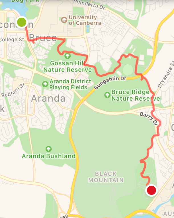
In the geography of the Canberra Centenary Trail, Mitchell is in a no-mans-land between the northern border section and the track heading from Belconnen towards Black Mountain and the City. The latter was next up on the agenda so I reasoned I could put my cycle to use, indulge in a walk towards the city, then get on a tram to pick up my car. A spanner comes into the works with the company of Alex; it took me a good half hour to figure out my day would need to involve: drive to Mitchell; drop off car; cycle to the Botanic Gardens; meet Alex; share Uber to Belconnen; walk; pick up bike and cycle to City; lunch with a friend; potter about while engine oil is being changed; take tram to Gungahlin; mill about in Gungahlin to kill more time until car is ready; bus to Mitchell; pick up car; pick up bike in City; home.
To be fair, the companionship of Alex has been almost always beneficial in managing the logistics of this walk, completing legs between A and B without the need to somehow get back to A. The gorgeous hike between Mulligans Flat and Hall would’ve been nigh on impossible without two cars. Yet a small part of me misses the challenge of coming up with contrived loop walks and cycle combos, adding significantly to the 135km of the Centenary Trail. In the first 50km of the trail, I covered almost 100 by foot and bike. In the second 50, 70, including my 10km ride from Mitchell today.
Still, it was a good feeling to not have to return to Belconnen after today’s walk. Commencing from the skate park, initial progress involved a tour through the uninspiring development of urbanisation in a public service town. The eighties feel lingers through solid concrete blocks and bus underpasses, a leisure centre next to McDonalds offering all the services one can ever yearn for. More modern developments rise but often give off that built on the cheap impression. More traffic lights go in and continually appear to have no sensitivity to actual traffic volumes. We cross the road eventually.
After a while, the trail veers away from the roadside and heads briefly into Gossan Hill Nature Reserve. This is one I had never heard of and appears to buffer the University of Canberra and Radford College with the suburb of Bruce. I know that a suburb called Bruce will be a delight to my British friends. I found it a delight too. Unfortunately, it is not named after every single cliché of Australian drongohood, but the eighth Prime Minister of Australia, Stanley Melbourne Bruce.
Suburb naming in Canberra typically takes two forms: one is the derivation of Aboriginal meanings and words (e.g. Narrabundah, Weetangera, Wanniassa). The other is a commemoration of prime ministers, stately figures, explorers, imperial invaders, and the like (e.g. Bruce, Curtin, Phillip, Mawson). Some of these suburbs go a step further with related street names – for instance, Lyons, who was Australia’s first and only PM from Tasmania, boasts a Launceston St, a Devonport St, a Tarraleah Crescent, a Burnie St, and a half-decent coffee shop. Just like Tasmania.
The peril of such an approach of course comes when good guys turn bad or bad guys are just recognised as bad or maybe, just maybe, some of these guys (they are always guys) are more complex than that, achieving some admirable things in life but doing so alongside other questionable and morally dubious sentiments and actions. I don’t know much about Bruce, but I’m sure he accomplished some worthy things in his career. However, he was also a big fan of the White Australia policy and played on this this during the election of 1925. How many of Canberra’s suburbs herald from men with similar dichotomies of achievement and displeasure, of thoughts and actions good and bad? Perhaps in future we should just go with Aboriginal names, at least avoiding the need to cement the likes of Abbott et al. into Canberra’s eternal fabric.
Because of its location in a place commemorating the eighth prime minister of Australia, Canberra Stadium is also still known in some quarters as Bruce Stadium. It emerges now through the gum trees, heralding an entrance to the Australian Institute of Sport. I quite like how the Centenary Trail takes you through here – it’s a bit different and offers insight into the world of an elite athlete. Perfect pitches, pristine ovals, gargantuan gymnasiums, and artistic inspiration celebrating antipodean achievements. In its heyday, the AIS was a world leader and helps explain how Australia came to punch above its weight in international competition. Funding cuts and other countries playing catch up mean it’s lost a bit of its punch in recent years and today – entirely devoid of people – it feels like a ghost town in a ghost town.

The trail follows quite a disjointed route to navigate the AIS complex, reminiscent of finding your way as a school student from English on the top floor of C Block to PE in the lower dungeon of the Main Hall via the tuck shop. At the AIS, you can get even more bewildered with the plethora of thoroughfares and walkways named after famous Australian sportspeople, several of whom I have never heard of. It pains me to find that the trail takes me along one of which I am all too aware – Glenn McGrath Street.
I don’t share much in common with Michael Atherton but I’m pretty sure we both used to properly hate Glenn McGrath. And it wasn’t just McGrath. All of them. The Waughs, Healy, Bowling Shane, Tubby Taylor, Gilchrist, Ponting, and so on and on. Frequent periods of Australian dominance over England leaves deep scars, watching as I was during university summers when the cricket – and so much else – was still on the BBC. Clinging to hopes of a miracle where the eighth wicket partnership could put on 322 to avoid the follow on and then be saved by two days of rain. And initially a glimmer of hope would appear, tail enders digging in and making a stoic 30, clouds darkening, Tubby chewing his gum at an elevated 600 strokes a minute. But then Tubby would chat to Gilly and tell Warnie to go over to Hussey to relay to Ooh-ahh that if he mops up these wickets he can go shoot some rhinoceros. And it would all be over as quickly as Geoffrey Boycott can say “maaaaikers neeeeeem”.
I still cannot bring myself to support Australia against anyone in the cricket.
Anyway, Glenn McGrath Street ended at the top of off stump and eventually the AIS terminated beside Gungahlin Drive. A tunnel led under the highway here and emerged upon Bruce Ridge. Bruce certainly got his money’s worth. After a little unintended detouring, the Centenary Trail coasted slowly down a cycle path, crossing the threshold from Belconnen to the Inner North. You could sense the change too, as older homes slowly emerged from the bush, nestled within spacious, leafy plots of garden. The last lingering of autumn was evident in the brown oak trees lining the sweeping avenues of O’Connor.
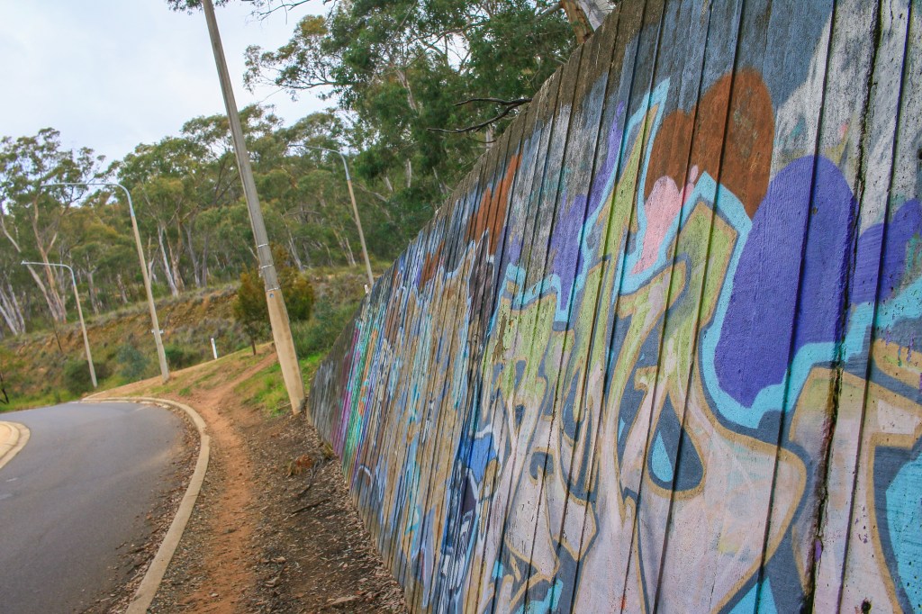
The route did little to intrude on the serenity of Inner North life for too long, instead heading into a surprising thin patch of scrub between the suburbs and Barry Drive. Strewth, what with Barry and Bruce in close proximity, this part of Canberra is so daggy. Trudging underneath a concrete tunnel decorated with street art, Alex and I no doubt looked the part too.
It really was an easy meander from here, passing beside the back of CSIRO and taking in more sights along the perimeter of an electricity substation. We were, effectively, on the lower slopes of Black Mountain. Here it is quite ragged, densely packed with trees, shrubs and bits and pieces of infrastructure. Yet through another gate the lower slopes of Black Mountain are charming, arranged naturally in an aesthetically pleasing style that invites an exploration of Australia: the Australian National Botanic Gardens.
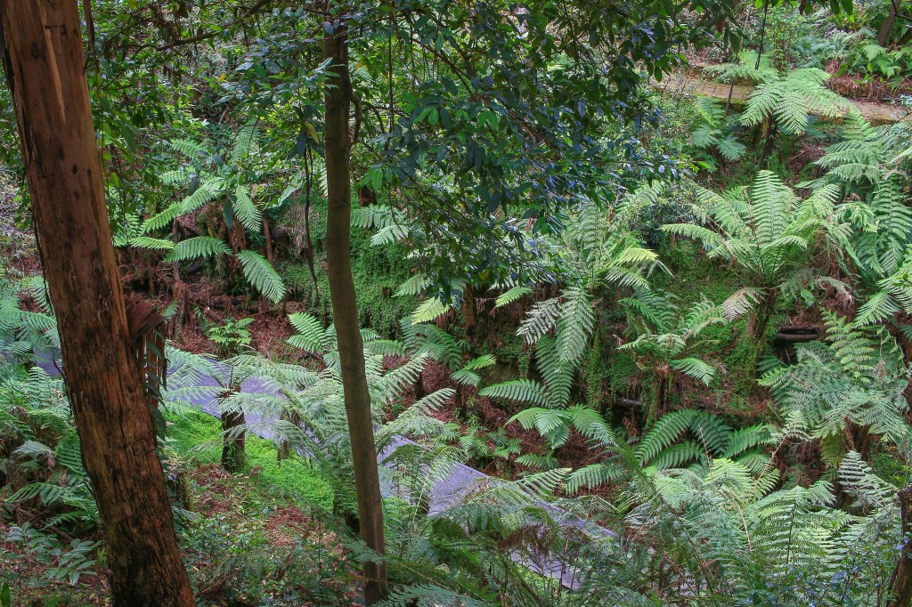
The Centenary Trail doesn’t go through the Botanic Gardens, ending today just prior to the Black Mountain Gate. But with my bike locked up on the other side, an amble through the gardens represented a delightful way to finish. I adore this place; many a time I have headed there not expecting much, to have a gentle walk, to kill some time, perhaps to embellish the experience with a fairly average coffee from the café. Yet every time I catch myself with a broad smile, neck arched up gazing into a canopy. Taking on board the aroma of golden wattle in winter. Feasting the eyes on the colours and contorted structures of a flowering spring. Baking in the red centre garden during summer and cooling down in the lush fern gully. Watching out for water dragons basking on the path, marvelling at the multicoloured sweep of everlasting daisies lasting ever onwards into autumn. Being reminded how unique, how precious Australia is, and how lucky I am.
Today the gardens were relatively subdued, indulging in a bit of a rest between late autumn and early spring. One of the more colourful adornments came at the end, with my hot red bike waiting to transport me away. Into Civic for lunch and a potter about. Onto Gungahlin Marketplace where I could kill some time. Down to Mitchell to collect a car. Back to Civic. Then home. Who said I missed such logistical challenges?
the numbers
Trail Section: Belconnen Emu Bank – Botanic Gardens
Trail length walked: 9.7km
Total length walked: 11.1km
Total steps: 13,250
Altitude gain: 190m
Wednesday June 24: Bush
The Australian bush is a complex affair. Being a catch-all term for any area of open space that isn’t the beach or the desert, it encompasses anything from a tangled reserve of ferns and frangipani in the Eastern Suburbs of Sydney to the sweeping golden grains of the WA Wheatbelt. As much as it signifies an imprecise array of plants and landscapes, ‘the bush’ is also a marker of otherness; a place beyond the modern cities and cosy towns where nature always holds the upper hand. To ‘go bush’ is to both head off for a jaunt into the countryside and to become slightly more peripheral and disorderly.
My first taste of ‘the bush’ was probably in Neighbours. As was so much of Australia, like the concept of a smoothie and teenage girls innocently using the term “spunk”. Anytime the bush was mentioned in Neighbours it was a portent of doom. Away from the suburban banality of Erinsborough, the bush was somewhere characters went to be savaged by snakes, trapped by fires, or attacked by creepy weirdos who had ‘gone bush’. It was a refreshing change when Harold Bishop got swept off a rock by the ocean to be honest. If he had gone bush, there would have been no memorable – or unmemorable – comeback.
Like many, I find the bush a contrary beast. At times it is the very delight of nature and open space, a theatre of beautiful white eucalyptus decorated with flowering plants and enchanting birds. The smell is often wonderful; if I ever leave Australia I’d want to bottle it. Yet the bush can also be a place of gloom and oppression, confining with its endless scrub, foreboding with its withering branches and dead undergrowth. Silence might be pierced by a black crow, wailing a guttural lament, as if drawing its last, painful breath in the sapping heat.
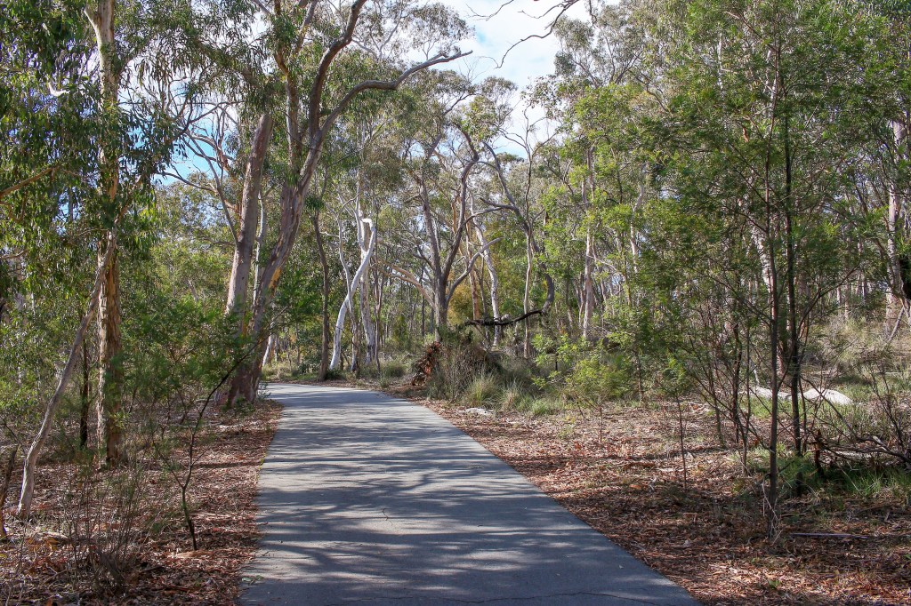
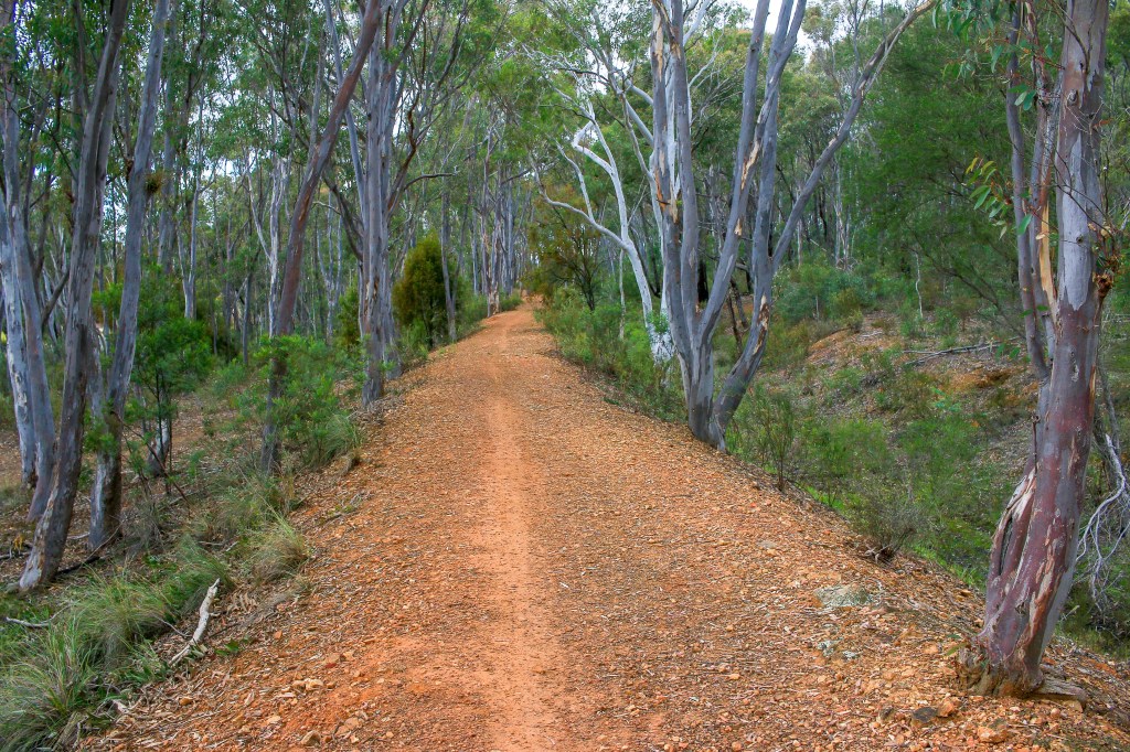
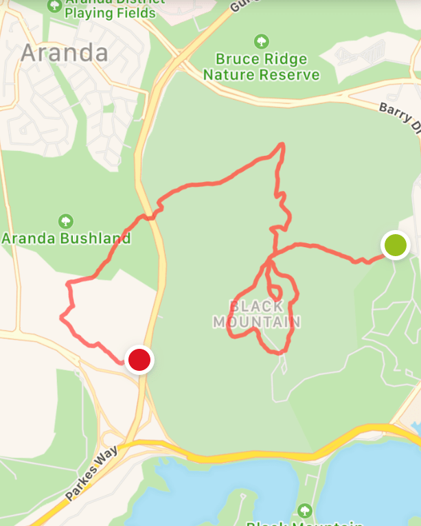
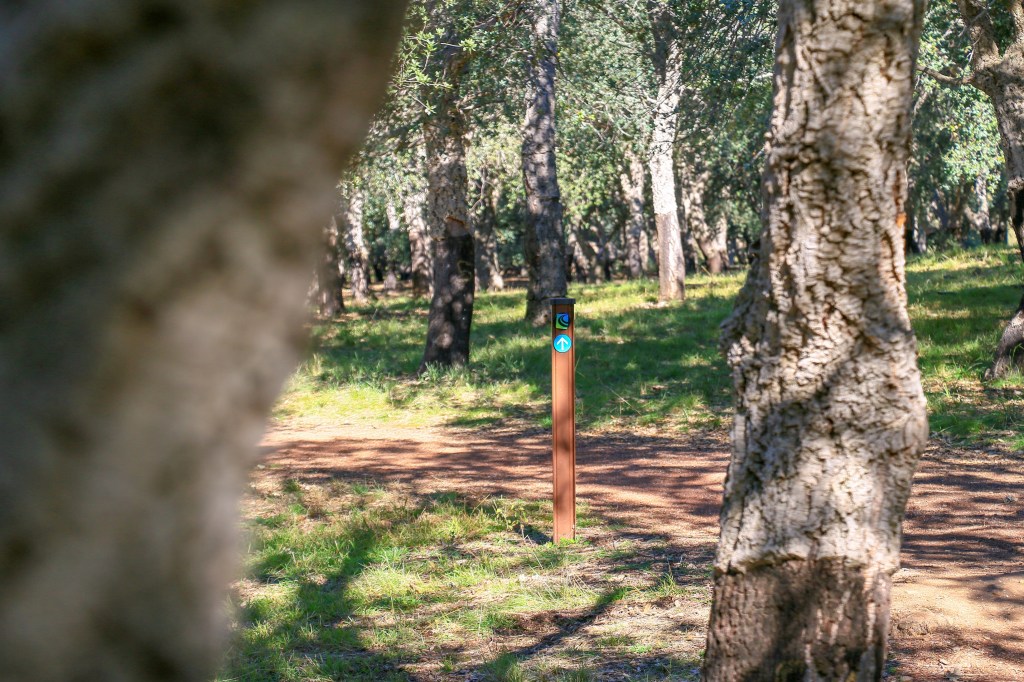
I wasn’t sure what kind of bush would be on the agenda for today’s Centenary Trail walk but the one thing that was certain was that it would be all bush. By which I mean forest. After some infuriating roadside and back fence meandering, the trail was heading into Black Mountain Reserve and, after that, Aranda Bushland. Just one road to slide under between the two. As well as a completely wooded-affair, today was also significant in that the Telstra Tower – that omnipresent beacon of my narrative – would be reached. In the process I should also clock up one hundred kilometres on the Centenary Trail, questionable recording methods notwithstanding.
The penetration into Black Mountain Reserve was immediately uphill, following a route I was fairly familiar with leading from the back of the Botanic Gardens towards the summit. As popular Canberra trails go, it is a fairly late addition to my life but now features irregularly as a conduit into the Botanic Gardens. Being a paid parking tight arse I have been known to park in an area midway up the mountain and head down this trail into the gardens, wandering around in a circle before heading back up. I love a free park and, while this is a decent option, nothing will be as satisfying as a hidden enclave of gravel somewhere around the Poldarkly popular Kynance Cove in Cornwall.
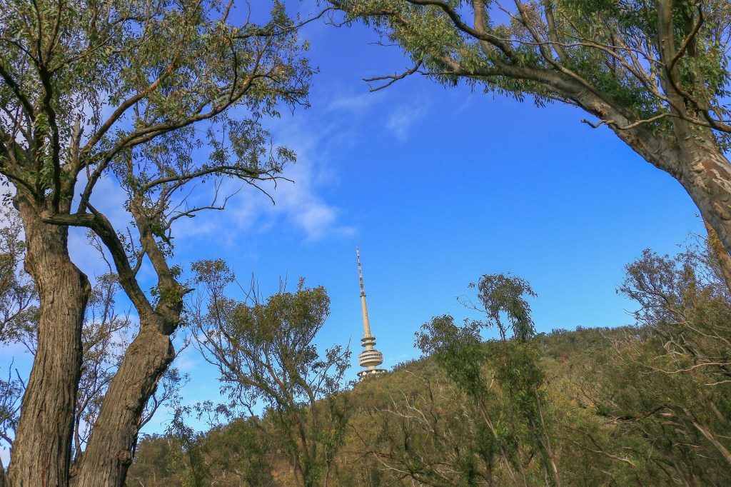
I’d say the bush heading up the hill here is pleasant and – at least under sunny winter skies today – lacks that threatening undercurrent of other, more murdery, pockets of bushland. Several pairs of Crimson Rosellas are out in force, their chirps as distinctive as their vivid red breasts. In between the trees the vegetation is quite sparse, leading to frequent views of that big concrete telecommunications tower becoming ever more prominent. It is drawing me close, sucking me in.
At a veritable Clapham Junction of a path, the trail signs point in several directions. Just the one of these is up, the final detour to the summit bringing weary pilgrims to the bastion of concrete and 5G laser beams that is the Telstra Tower. A large car park laughs in the face of weary walkers and exhausted cyclists, while a small platform provides broken views of Canberra through the bush. It is still with us.
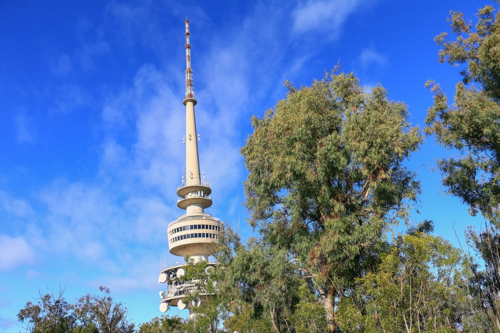
You really do need to go up the tower to get clear views from the top of Black Mountain. There’s obviously an admission charge, though today the structure is closed, which is a bit of a shame because there could have been a coffee and cake opportunity. I have been up there on a few occasions though, once for finer dining. This was in the era of revolving restaurants and I will never forget the disorientation of getting up to find the toilets in a different position to where they were before. Either that or the wine was doing a good job.
On the ground, fine views emerge in gaps around the perimeter path, which again links up with the Centenary Trail signage at Clapham Junction. The better vistas are off to the south and west, with the western part of Lake Burley Griffin set among other hills and suburbs rolling towards the mountains. Green pasture creeps down to the Murrumbidgee River, unseen but unmistakably present in the fold of land before the Bullen Range. And there is still lots of bush, seemingly spreading unendingly right up to the feet of towers and cranes marking Belconnen Town Centre.

It is into some of this bush that the trail now descends, steeply at first and with a concerted period of zig-zagging. On flatter terrain, the trail is more comfortable, wider and well-groomed for leisurely cycling, with plenty of light penetrating the thin canopy of eucalyptus. It is, to some eyes, unremarkable, monotonous, dull even. But it is not a bitumen cycle lane adjacent to a busy trunk road, nor is it a concrete underpass leading to an electricity substation. It is the bush and be thankful for that.

For people missing concrete underpasses there is a small consolation. Something of this ilk emerges to facilitate access from Black Mountain Reserve to Aranda Bushland. Above is Gungahlin Drive, a busy north-south route that had previously been tunnelled under on the last leg. On its western side, a wide dirt track follows the road and heads steeply uphill, causing momentary consternation before a trail marker indicates an escape to the left. Into the bush.
Aranda Bushland is, at first, remarkably similar to Black Mountain Reserve in that there is bush and some bush and a bit more bush. At some point though the trees thin out to present a more open, grassy form of bush. It feels like land that was cleared by marauding squatters, quickly to be overgrazed and ultimately degraded. The nearby bald mound of Mount Painter testifies to a form of bush stripped down to its essentials by the voracious demands of sheep.
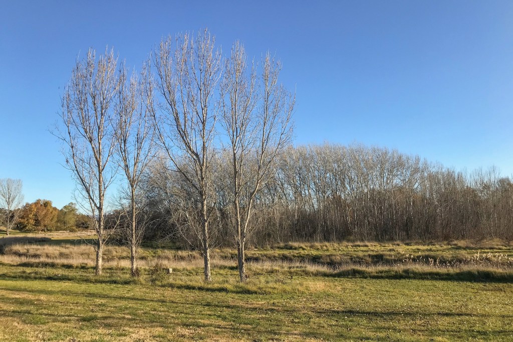
Yet there are remnants of a purer kind of bush in a cluster of snow gums that grow here. These represent some of the last survivors of what used to be a continuous ring of snow gums encircling the frosty hollows and flats of the Molonglo Valley. Nowadays you only tend to see snow gums on the higher alpine slopes, gnarly and stunted with smooth, variegated trunks revealing striking strips of colour. But as late June bites in Canberra, it isn’t a stretch to imagine the arctic chill of an exposed frost hollow providing perfect conditions to nurture a snow gum or two.
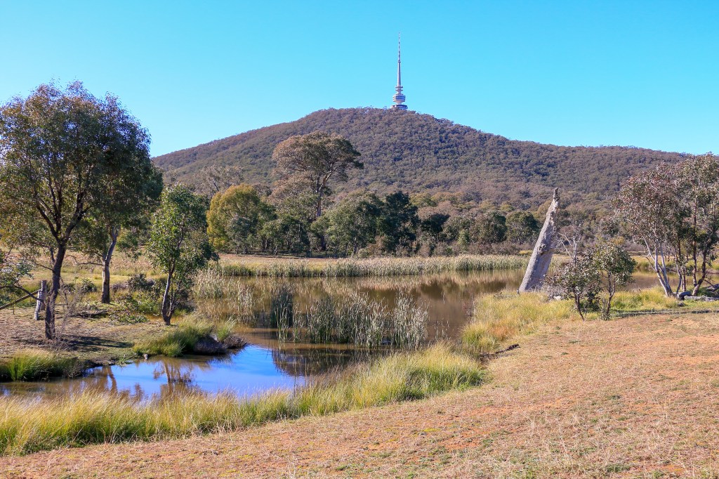
Approaching noon on a benign, sunny day, I am pleased that conditions are far from polar. Beyond the snow gums and a dead calm dam a car awaits in a parking spot beside Gungahlin Drive. I can’t quite see the car, hidden as it is among a clutch of trees. Trees which gather and rise to spread across the flanks and folds of Black Mountain, topped by that tower. The beautiful, enchanting, beguiling, menacing bush; host to an inescapable landmark, an enduring symbol of this walk.
the numbers
Trail Section: Botanic Gardens Black Mtn Gate – Aranda Bushland Car Park
Trail length walked: 8.5km
Total length walked: 9.0km
Total steps: 11,300
Altitude gain: 250m
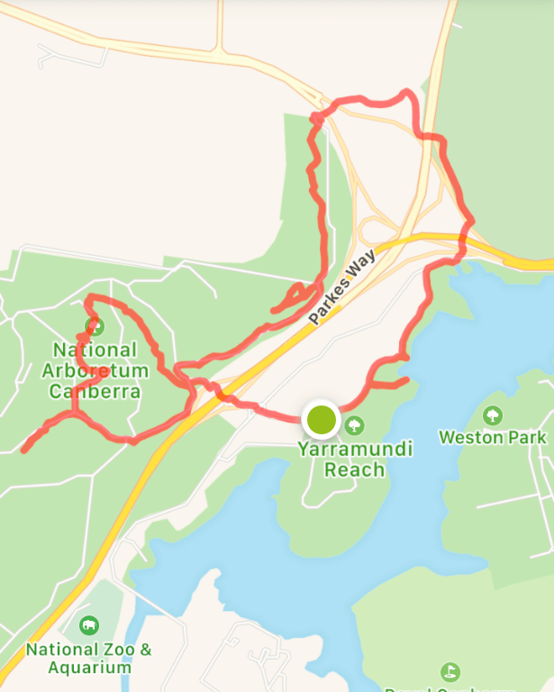
SUNday June 28: Losing track
Coffee walks have become a common feature of my life. Some days it’s more about the coffee than the walk. On others the walk is king, with a flat white in hand proving the jewel-encrusted crown. Sometimes – and probably more during this pandemic – the coffee walk has been an event to get out, to see other humans at a distance, to break up the day. Something to do. An experience far more satisfying than my disgusting forays into instant.
I wasn’t particularly intending a coffee walk today or a Centenary Trail walk either. It was all a bit spontaneous. The wait for a takeaway in warming rays of sun offered inspiration to stay out in it a bit longer. Why not knock off some more kilometres under such fine weather with a jewel-encrusted crown in hand?

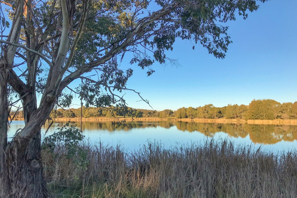
Spontaneity meant, of course, a little extra work. Like formulating a loop that would take in some non-trail trail as well as genuine trail trail. Fortunately, the non-trail trail link took me along one of the more scenic backdrops, bordering Lake Burley Griffin on its western shores. Here, away from the busy cycle lane, the area is fairly untrammelled, full of golden grassland and eucalyptus groves. Long reeds fringe the water and protrude into the lake, forming small headland sanctuaries for reptiles and birds. Among a cluster of trees, a wooden table offers coffee and contemplation with the fairy wrens.
From such idylls, it wouldn’t be a Centenary Trail walk without an underpass or two to bring you back down to earth. These take me through Glenloch Interchange, two words that feature regularly in the morning and evening traffic updates on the radio. Canberra’s answer to Spaghetti Junction, only more of a lone Farfalle sparingly seasoned with salt and pepper. With my coffee now exhausted and the concrete increasing, the walk is once again dipping into unfavourable territory.
It doesn’t last too long though, the final underpass providing an enticing gateway into the northern edge of the National Arboretum. A flurry of creaking cyclists crawl on by as I peruse the map. It’s a map with multiple trails and markers, numerous tracts and plantations. While a Centenary Trail icon is shown in the legend, this just seems to state the truism that the Centenary Trail is present within the National Arboretum; there is no clearly colour-coded line wiggling its way over fields and through regimented rows of saplings.
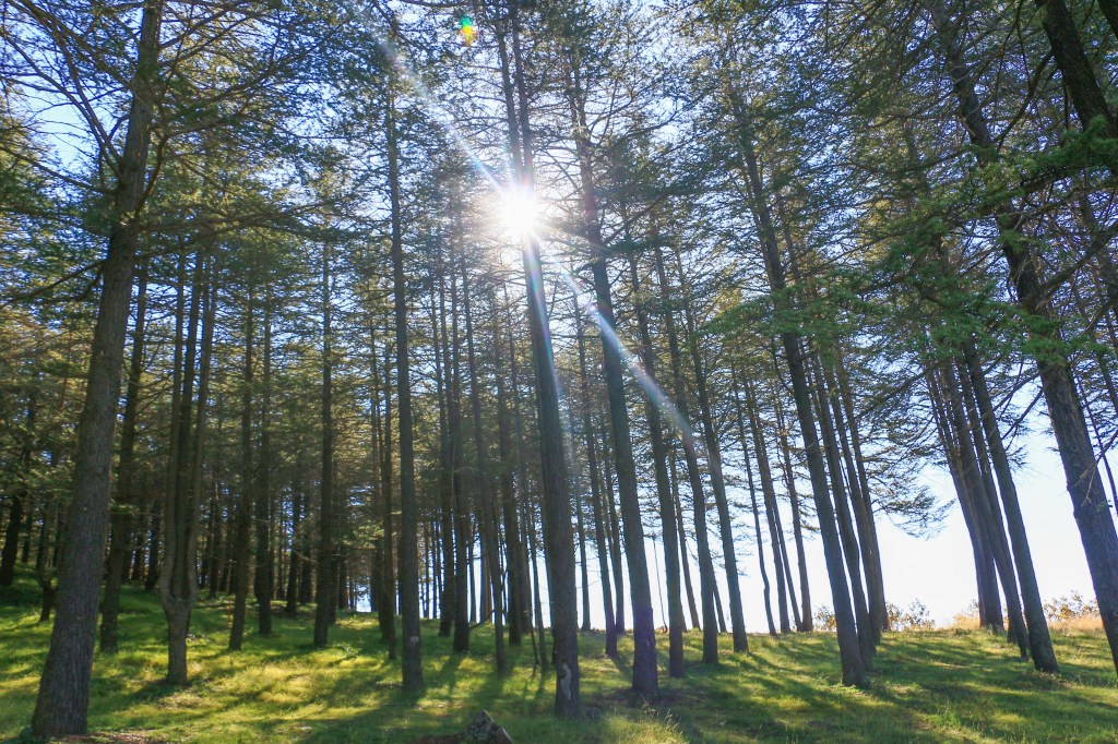
Still, the marker posts exist for now, pointing me on into the Cork Oak Forest. This section of the Arboretum was here well before the Arboretum. In fact, it was born around the same time as Canberra over one hundred years ago. None other than Mr Burley Griffin himself considered the potential for cork growth in Canberra’s climate, and sourced the original acorns from the Royal Botanic Gardens in Melbourne. I like to think he was keen to survey the capital from here and toast his success with some well-preserved wine. Or perhaps cognisant that future generations would need a bottle or two to get through winter.
There is a timeless, otherworldly feel within the Cork Oak Forest but all I can think about is wine. Unfortunately, all I can hear is whine, whine, whine. A small child has fallen from a bike and it really is the end of the world. I know the feeling love. Get used to it.
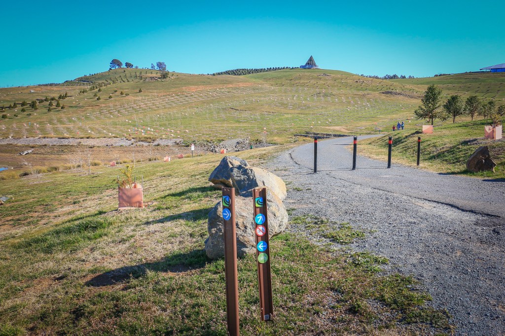
It really is busy here, highlighted by tens of cars parked in the gravel nearby. On the hill ahead, the dark green of the Himalayan Cedar Forest – another long established plantation – attracts the masses. A track winds up into its fragrant woody depths and I assume this is where the Centenary Trail is destined to lead. The one sign from across the car park is ambivalent about it, but you’d think the trail would direct you into another unique element of Canberra’s early history. Rather than, say, an exposed dirt road close to the Tuggeranong Parkway.
Yet that is to forget the Canberra Centenary Trail’s frequent propensity to take the stupid route and ignore the advantage of more scenic and amiable pathways. I get this at times since the trail – apart from walker only detours or extensions – is supposed to be suitable for cycling. But here most of the bikes I can see are heading up into the forest on a purpose built track. Even the young kid is back on her bike and giving it a go. From the forest you could pause at a viewing platform, take a nature break in the loos, have a selfie with the ‘Wide Brown Land’ sculpture, and easily carry on towards the visitor centre. But no, a dirt road shared with cars leading you to another junction.
At least the dirt road fringes the bottom of the Himalayan Cedars and an outlook to the south and east opens up over the parkway. There is even, finally, a sign confirming that you are on this ridiculously plotted section of the Centenary Trail. I really would draw it up a bit differently; indeed after this is all done that’s probably what I will do. The Canberra Centenary-7 Corona Trail.
Rubbing salt and perplexity into the wound, the next sign directs the walker either left, right or straight up the hill towards the visitor centre. I say straight but the path has been designed in zig-zag fashion, partly to reduce the gradient of the climb for all visitors and partly to complement the design aesthetic of terracing and plantings flowing down the slope. I don’t know how many zig-zags there are in total, but I gave up after ten, opting for a well-worn track straight up the slope. Technically I may have veered from the Centenary Trail but technically the Centenary Trail just seems to vanish within the Arboretum.
Which is discordant given the National Arboretum was opened in 2013, as a one hundredth birthday gift to the citizens of Canberra. During the centenary. It’s been a fine addition to the capital, with fantastic views, striking design, good facilities, and much to commend in terms of research and development. People often say about the Arboretum it will be great in twenty years. When the trees have matured. Apart from the Cork Oaks and Himalayan Cedars that were saved, much of the land was a bare hill, stripped of vegetation in the 2003 bushfires. To see it today is to feel a certain civic pride and sense of hope for the future. Recovery happens. Trees will grow.
I learned a bit more about the Arboretum one summer evening, as part of series of open days. What sticks in the mind is that the temperature that day was something like 38 degrees. By the evening it had cooled down to 35 degrees and I joined a guided walk up to Dairy Farmers Hill. Hot topics for discussion included how to manage plants in drought, trialling different watering systems and bushfire mitigation. I suspect the weather may have had a lot to do with such talk. A cheese platter at the end of the walk was also memorably melty.
Today it is unclear if Dairy Farmers Hill is on the Centenary Trail. My PDF map suggests not. A marker points towards the visitor centre and I dutifully walk through the hubbub and out again. A few purpose-built gardens housing bonsai and herbs and cacti attract interest, while families are picnicking and flying kites and roly-polying upon a green bowl of an amphitheatre. Plenty of attractions and among them not a Centenary Trail sign in sight.
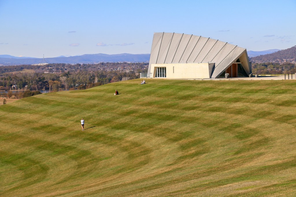
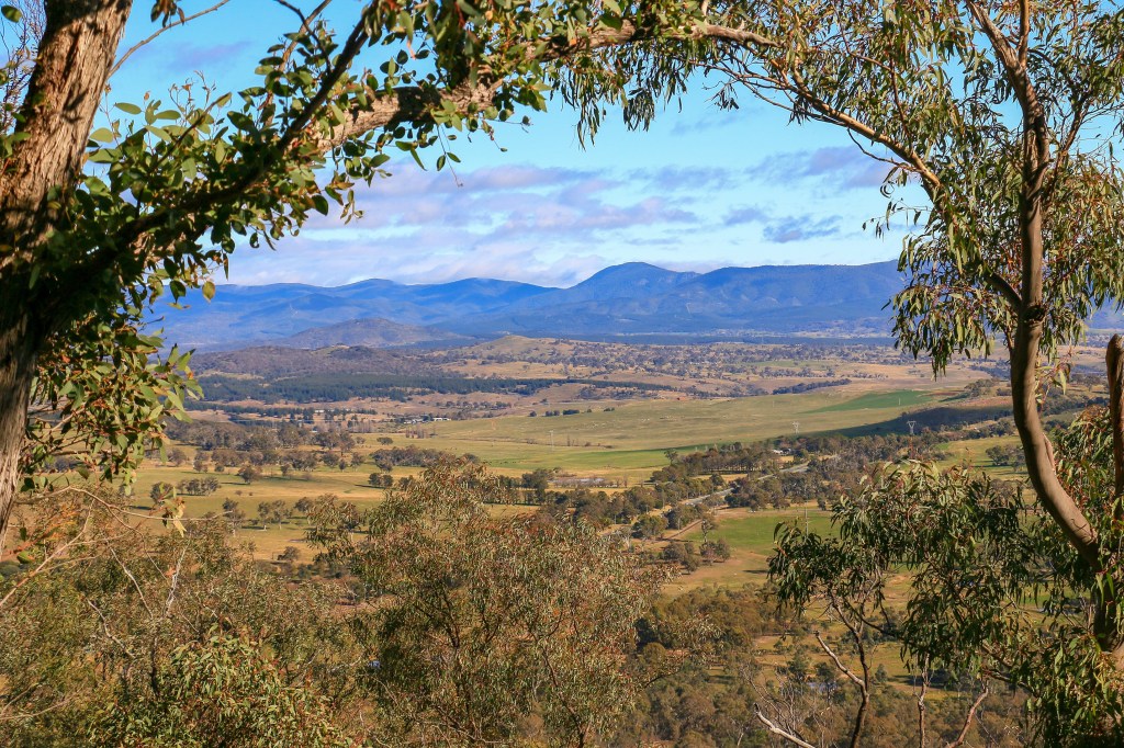
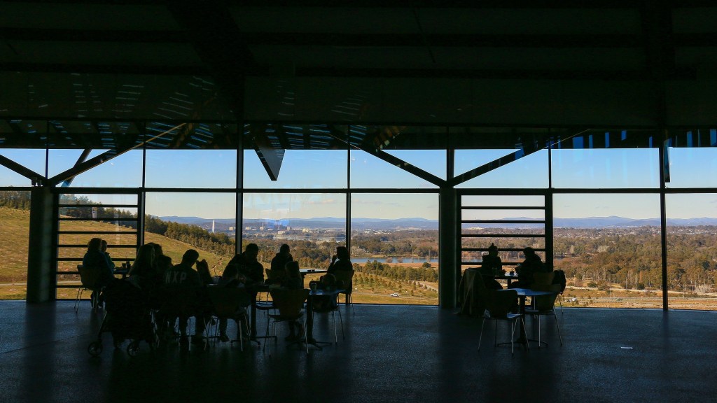
There was to be great poetry finishing up at Dairy Farmers Hill, the beacon upon which much of Canberra can be viewed. A culmination to the latest section of footsteps and writing, with views of what is still to come. I might have even regaled you with epic quests to cycle to its top on Christmas Day, justifying later consumption of an entire Christmas pudding. But I will have to make do with a bench beneath its summit, looking out over some immature saplings and the parkway below.

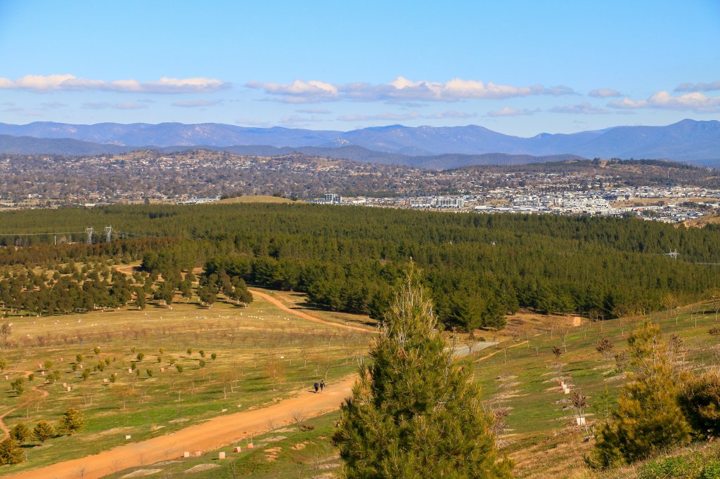
There is still elevation here and I can spy the route down the Murrumbidgee to my right. Hopefully, there will be some more conveniently placed coffee stops along the way. And reliable signage. Now, if only I could find out how to actually get there.
the numbers
Trail Section: Aranda Bushland Car Park – National Rock Garden
Trail length walked: 7.0km
Total length walked: 10.1km
Total steps: 11,300
Altitude gain: 121m
