Route: Panorama Chairlift-Saltner Hutte-Schlernhaus-Seis
Approximate distance: 12km
Start / Finish: Panorama Chairlift, Seiser Alm
Highlights: Attainable Dolomite views amongst a meadow-filled landscape

Sometimes you just have to wing it. Lacking a good map, clear signage and – nowadays – mobile internet access, finding the right way forward may boil down to good old fashioned instinct. Is instinct sufficient though? I guess it depends on the situation at hand and an ability to – paradoxically – apply a rational, logical filter to spontaneous guesswork. At a fork in the trail, what is the most likely path to take? Instinct Without Intelligence Is Ineffective. And there you have my entry into the world of insipid inspo quotes.
Being in a place where the language is all muddled may have been a factor in making this Dolomite hike a little more difficult to interpret. Up in the high country of northeastern Italy, in which small towns boast ample pizzerias and gelaterie, German seems to dominate. This is an undoubted consequence of mountain confinement over the years, individual valleys protected from the creeping spread of Mario and Luigi and that guy who sang Shaddap You Face by the sheer cliffs and spireite pinnacles of this most jagged of alpine ranges. The Germans probably bore their way in.
Indeed, I came to this place from Germany, on a soporific train ride which was punctuated by gargantuan scenery as it passed through a small sliver of Austria. Alighting at Bolzano / Bozen, sprawling in an arterial valley, my first attempt at trilingual communication was to buy a Bolzano Bozen Card, gateway to attractions, transport and – most importantly – several cable cars and lifts up into the hills. That afternoon, my first cable car was illustrative of a few days lost in translation, as the card seemingly did not apply to this particular journey.
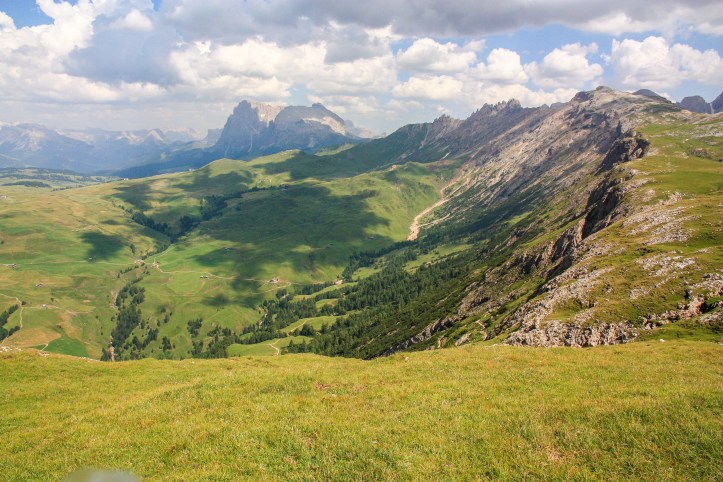
People spoke to me in German up top, and so from now on I am using German names where applicable to describe this slightly improvised hike up in the Seiser Alm. This expansive upland plateau was reached via bus from Bozen (covered by the card) to the small town of Seis Am Schlern, where I took a couple of lifts up a further thousand metres to the tightly compressed village of Compatsch and on to the top of the Panorama chairlift. Revealing a panorama of open green meadows, scattered with wooden chalets lapping at the seemingly impenetrable hulk of the Dolomites.

The closest hulk of mountain proves the most alluring, the protruding isthmus of Schlern, capped by Mt Petz and extending into the landscape via the pleasingly Germanic Santnerspitz. I will head there, guided by the semi-decipherable map that came with my cable car ride, the occasional signposts, a giant pretzel supplemented by sausage and cheese, and a small dose of intelligent instinct.
The initial going is a doddle, mildly undulating along a wide trail with views in every direction. Chalets provide landmarks and before too long one of them emerges as a rustic hotel-restaurant-bar – Baita Laurinhutte – so typical of alpine climes. To stop and have a drink now is tempting, but the day is still young and a mountain still awaits.
From this point, various gravel roads and tracks diverge and I happily take what proves an effective method to get to the base of the climb. It veers gradually left and heads slightly downhill into a small valley, accompanied by another basic but hospitable looking drinks terrace bathed in hot August sunshine. This turns out to be Saltner Hutte and is the last chance for a touch of placidity before the going gets tough.

You may be thinking he seems to know totally where he is going, but that neglects to take into account the fact that I am writing this several years after the event, armed with the internet and the ability to deduce locations and place names. Even this is proving challenging, recollecting steps I took by examining 3D map contours and matching snatches of buildings in my photos with images googled on the web.
Back then, I was relying primarily on the cable car map. This naturally wasn’t to scale, omitted numerous landmarks and tracks, and lacked detailed calculations of altitude and contour. It wasn’t bad – exactly what you would expect to tell the truth – but it definitely left plenty to the imagination. This included the upward slog now facing me, looking innocuous on paper but in reality a grind. A despair magnified by the heady notion approaching this day that I would be climbing the mountains by cable car and walking all the way back down.
Sometimes ignorance is bliss. But so too are the rewards of a climb in a mountain landscape, first steepening over tumbledown pasture before winding through pine forest and lumbering out into increasingly bouldery, open terrain. Each step up presents an extension of the vista, as though affixed to some slow motion drone filming the remake to The Sound of Music.
 At the top of the climb, the pasture is suitably lush and perfect for a sing song or a pause for a picnic lunch. I embark on my classic mountain hiking feast, which I conclude is enough to encourage frequent mountain hiking. Many others have sought refreshment in the Schlernhaus just around the corner, a large brick hostelry which comes as something of a surprise given the largely solitary path I have taken thus far. How did they get up here exactly?
From this spot, the views are terrific, especially to the jagged ridge of the Rosengarten, crooked and eroded like the bottom row of some seriously bad teeth. Nearby, the summit of Petz appears more rounded and attainable, regularly populated by walkers who have seemingly appeared from nowhere. I speculate whether there is a lift tunnelling through the mountain to the Schlernhaus which might explain the easy jauntiness of these figures.

For I am feeling a bit spent. It’s hot, and clouds are gathering in that way which often signals a biblical storm is going to emerge later in the day. I’m also conscious of the need to somehow return to the town of Seis, 1500 metres below, in time for the bus back to Bozen. Petz can wait for another day, or – more realistically – not at all. Looking back at the maps now, there’s a tinge of regret that I didn’t just push on, particularly as I could have rewarded myself with an ice cream at the Schlernhaus and ended up with plenty of time waiting for the bus. But I wasn’t to know.
And so, my path back from Schlernhaus followed the same route down the mountain, at least until I took a turning left into the valley to head directly towards Seis. With each step down, the meadows become magnified, the flowery details of chalet window boxes gaining clarity. Eventually the vistas disappear and you tread carefully down a series of rocky switchbacks through the pines, criss-crossing the detritus of spring floods as the trickle of a stream obeys gravity. Keeping this stream – the Weiberbach – close is a sound strategy to find your way back, though I’m not sure I would recommend this route if you had more time.

After what seems an eternity, the route begins to level out and signs of greater civilisation emerge – gravel roads, sprawling homes, succulent meadows chewed by cattle. The stream widens and loses pace, meandering gently under small bridges and gathering in shady pools. My instinct has proven effective as the town of Seis begins to congregate, a pretty place with a gelaterie to offer comfort. Perhaps having a little time to kill before the bus back was a good thing after all. Stracciatella and Black Forest, staring back up at the blended Dolomitian flavours I just knew I would adore.

Extra Steps
- Bozen / Bolzano proved a good base to explore the area, particularly armed with a Bozen Card. The town itself is pleasant enough, with ample piazza and window boxes. Various buses head off to various mountain villages, while three cable cars lead up into sunny plateaus and forests from the town.
- Closest to the railway station, the Renon cable car is the most contemporary experience, commencing fairly close to the railway station and rising up through vineyards with breathtaking views. Up near the top a narrow gauge scenic railway can extend the trip, with plenty of opportunities to hop off and meander.
- The Colle cable car departs on the south side of the river near the motorway, presenting an inauspicious start. This rises up steeply over dense forest and there is not a great deal up the top, with the forest still dominating; the best way to get a view is to climb a large wooden tower they plonked nearby.
- The Jenesian cable car is a little out of town but proves old skool with a capital sk. Very compact and (in summer) hot, the operator has to ring the top before departing. Perhaps ordering a cold beer as there is a sunny terrace to soak in the views.
- There are obviously loads of walks in this area and I would be more than happy to go back. Even from Seis / Suisi I can see numerous other options I could have taken on this day. The area is also renowned for its precipitous Via Ferrata.
Links
Get your Bolzano Bozen Card: https://www.bolzano-bozen.it/images/BZ_Card_Plus_Folder_17.pdf
Bozen cable cars: https://www.bolzano-bozen.it/en/cable-cars-bolzano.htm
That cable car map: https://www.seiseralm.it/media/1d935f5d-2910-42fb-86a8-051a872dae26/sommerkarte2019.pdf
Take refuge at the Schlernhaus: http://www.schlernhaus.it/schlernhaus/en/
Some more details on this trip to Italy: https://gbpilgrim.com/2013/08/08/hallo-italy/
