Key Summit, Fiordland, New Zealand
Route: Routeburn Track onto Key Summit Track
Approximate distance: 7km
Start / Finish: The Divide
Highlights: A taste of an iconic Kiwi tramp through mountainous wilderness, offering significant reward for relatively little effort

The road between Te Anau and Milford Sound on New Zealand’s South Island is undoubtedly one of the most magnificent stretches of bitumen anywhere on this or any other Earth. Forested hills, button grass plains, and glacial rivers succumb to precipitous overhangs and jagged mountains, the other side of which leads to a peculiarly subtropical style landscape of giant ferns and gushing waterfalls. The obligatory cruising on Milford Sound can prove something of an anticlimax following the journey to get there, but it offers a nice well-earned rest on the water before the return beckons.
Understandably this is a popular tourist drive, with frequent turn outs and parking bays for reflective lakes, gurgling rivers, crashing falls, and grassy meadows. Often of the get out of the car, stretch the legs and take a few snaps before driving on to the next one variety, they are staples of the coach tour itinerary. In the peak of the day, these strategic stops can be quite hectic, sometimes necessitating several loops before a parking space appears. And with this, some of the shine of the often magnificent drive can wear off.
The solution to escaping such frenzy appears to be to set off early or go later in the day and – if time allows – embark on a longer walk away from the scenic stops. Not that this will deliver solitude since the multiday tramps in this area – Milford, Routeburn and Hollyford – are often booked up well in advance. However, with each step from each car park, the sense of connection with the landscape increases and the unwashed odour of campervan air fades. The universal appeal of tramping / hiking / bushwalking / rambling encapsulated.
One such walk leaves from The Divide – one of the parking stops along the road – and follows a small section of the Routeburn Track before it turns off to Key Summit. From here there is little, if any, sign of human intervention, just the pure wilderness of Fiordland all around to admire. Obviously only if it is sunny and clear, which isn’t always a given in this part of the world.

It was late afternoon when I approached The Divide from Te Anau with my travelling companion Jill. We had just come from the far south of the South Island where it was cool and dreary, and we very nearly ran out of petrol in a small town that possibly harbours banjo-pluckers and mass murderers. Imagine our relief, then, to find ourselves under blue skies with a three-quarters full tank of fuel cruising through the beautiful Eglinton Valley. There was a kind of pinch-yourself quality to all this.
Stepping out onto the Routeburn Track it doesn’t take long for the terrain to rise, though the shade from the lush canopy of Beech provides respite from that now-penetrating sun. Cloaked in by the foliage, there are only snatches of view to be had – an occasional lump of rock here, a few millimetres of valley there. People with hefty backpacks pass by from behind as fresh as a daisy or cross on their way down looking a little wearier and more pungent. The sense of enthusiasm of starting off on the Routeburn is infectious, even if you are only going a little way in.

After approximately two kilometres, the tree line begins to thin out and the path continues to wind slowly upward onto open, mossy terrain. Not long after, the junction for the Key Summit Track appears, with many a hefty backpack eagerly continuing on the Routeburn towards their first overnight stay. Some might add in the detour though, and I doubt they would regret it.
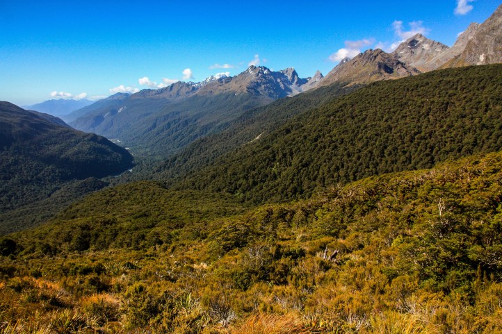 Indeed, it is possible to question if they will come across anything as satisfying on the rest of their tramp, with 360-degree views framed by the mountains of the Humboldt and Darran Ranges. The summit itself is barely a rise in the sub-alpine moorland, reached via a meandering track past a series of small tarns and hardy shrubs. There is a marker and some information about surrounding landmarks, of which there are many. Cars and coachloads are nowhere to be seen.
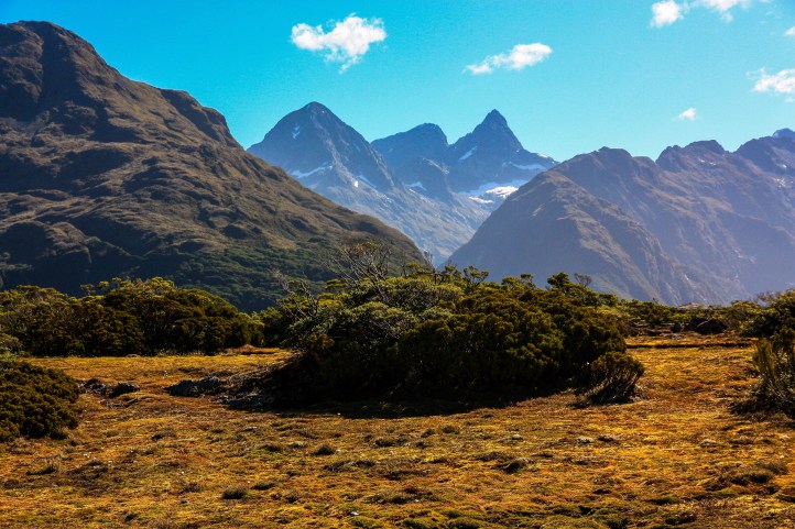
 There would be a temptation to turn right onto the Routeburn to see what else is out there, because going back down feels like you are giving something up. Giving up the chance to encounter that which is less often encountered, soaking up a world that cries out to be soaked up, making the most of blue skies that are surely an intermittent sight. But the day is moving on, and we need to find a sleeping spot for the night. The return route is along the same track, only it’s a path on which you now feel more content, more heartily fulfilled, more alive in this very time and place. And there is still the prospect of a quiet, sun dappled drive through this earth which you can now appreciate with illuminated clarity.
Extra steps
- Timing is key to getting the most out of Fiordland; setting out at dawn or leaving it to later in the day can make a world of difference, as most of the coach tours emanate from Queenstown and peak traffic is typically between 10 – 4.
- You can’t come to this part of the world and not do a cruise on Milford Sound. There are several operators and while they proclaim to offer unique insights or added wildlife expertise, they seem much of a muchness to be honest. Again, doing an early or later cruise will provide a more spacious, easy-going experience. You can also do overnight cruises and kayaking adventures and the like.
- Whatever cruise you choose, make sure you give yourself a bit of time either before or after to explore around the bays at the Milford Sound terminal – there are a couple of short boardwalks and – weather and tide permitting – iconic views of Mitre Peak reflected in the water.
- There are several Department of Conservation camping / caravan spots along the Milford Road, though these are all prior to The Divide coming from Te Anau. The pristine Eglinton River often provides a backdrop to these sites and, surrounded by forests and mountains, there can hardly be a better place to stay. Unsurprisingly, they can get busy in peak season and I hear they are popular with fly fishing folk too!
- Te Anau is the gateway town to this area and while it’s not huge there is a wonderful ambience beside the expansive blue of its namesake lake. There are also a surprisingly large number of shops, cafes, takeaways and tour operators based here, as well as crucial petrol supplies.
Links
DOC information on Key Summit walk: https://www.doc.govt.nz/parks-and-recreation/places-to-go/fiordland/places/fiordland-national-park/things-to-do/tracks/routeburn-track-key-summit-track/
Fiordland National Park: https://www.doc.govt.nz/parks-and-recreation/places-to-go/fiordland/places/fiordland-national-park/
DOC Fiordland campsites: https://www.doc.govt.nz/documents/parks-and-recreation/places-to-stay/campsite-information/campsites-fiordland.pdf
NZ tourism – Fiordland: https://www.newzealand.com/au/feature/national-parks-fiordland/

I opened this for the Centenary trail read – as want to do home to Red Rock Gorge – then discovered this gem,
We were there in Jan and was a stunning day when we drove TeAnu to Milford – had to keep stopping.!
LikeLiked by 1 person
That road sure packs a punch. No Red Rocks Gorge on the trail yet…heading north next. But I did do that walk anyway recently, from Kambah Pool. Water should be even higher now! Bit of blurb here: https://gbpilgrim.com/2020/04/02/walking-is/
LikeLiked by 1 person