Route: Burrator Dam and Sheepstor loop
Approximate distance: 4km
Start / Finish: Burrator Dam, near Dousland, Devon
Highlights: Peaceful waterside strolling, ancient mossy forest, quiet country lanes and open moorland views. Good chance of ice cream.

Dartmoor National Park contains the largest area of moorland in southern England and it is entirely possible to find spots where you will not see any sign of modern human intrusion. In fact, you won’t see much at all in one of the moor’s classic fogs. Even when it clears, the landscape can seem barren and devoid – think windswept open uplands, boggy marshes, and rocky granite tors, fractured by ice, gales, blizzards and rain. Yet it is this stark emptiness which is a big part of Dartmoor’s allure in a country so degraded and devoid of genuine wilderness.
There is also the more sedate Dartmoor with cutesy thatched villages, drystone walls enclosing bleating lambs, babbling brooks spanned by ancient bridges, and several spots for a bona fide clotted cream tea. Having grown up in nearby Plymouth, this is the Dartmoor of childhood memories, often with Uncle Ian and Aunty Pat and their dog BJ, frequently culminating in a Willy’s ice cream. I didn’t realise how lucky I was at the time and – now being estranged from southern England – it is only in the last few years that I have rediscovered what a special place Dartmoor is.
This is a walk I made up on one of my recent visits and it was so pleasant that I have repeated it several times since. With easy access from Plymouth, it’s a brief but diverse journey through the quintessential landscapes of Dartmoor, encompassing ancient and slightly eerie forest, narrow country lanes, patchwork fields defined by crumbling drystone walls, a cutesy hamlet of cottages and churchyards, and a dose of upland wilderness with 360 degree views. There is also a good chance of a Willy’s ice cream at the end.
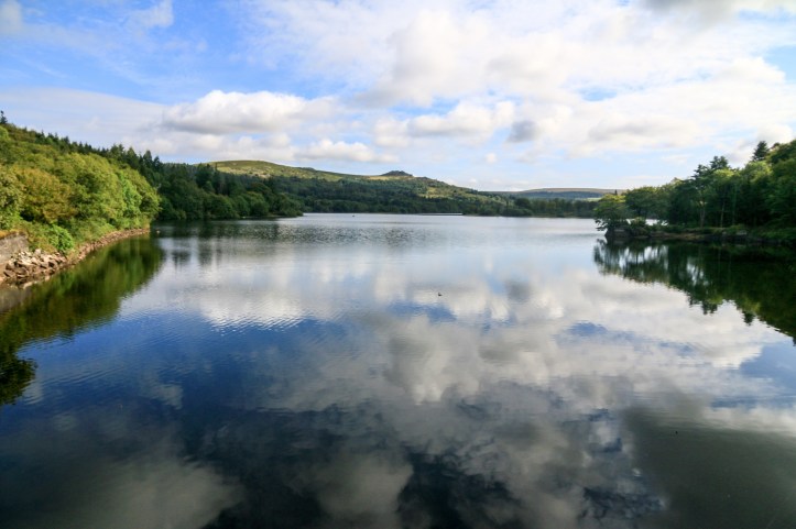
Approaching from the village of Dousland (turning near the pub), I parked up beside Burrator Dam wall, which is a popular spot for both grockles and locals seeking a spot of fresh air. Here are expansive views of Burrator Reservoir, set within a backdrop of forested banks and exposed tor-capped hills to the north. Burrator provides drinking water to the city of Plymouth and if you walk the streets of Plymouth sometimes you may well question ‘I wonder what they put in the water’. Plymouth is my birthplace, so I feel I can get away with saying this.
 After following the road across the dam and gently up through a wide sweep of deciduous woodland, a gate on the left took me off the tarmac and once more alongside the water. This followed the more subtle and less impressive Sheepstor Dam Wall before a sharp left turn into more leafy woods. There is something enchanting about these woodlands, the trees flush with green from the generous rain and sheltered setting, penetrated by dappled sunlight and the occasional squirrel.
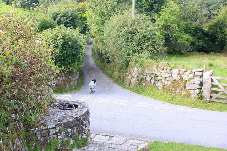
The path soon emerged onto another road but calling this a road is probably way too generous. It was actually the road encircling the reservoir and a few intrepid cars and vans squeezed their way through the blind bends hemmed in by steadfast granite walls. Keep ears open here! However, by and large it was quiet, as I ambled south towards a junction and then left towards the small cluster of cottages centred around St Leonards Church. This is where things became even more idyllically Devon, with a small clear brook babbling beside the lane, charming stone buildings, and a peaceful ambience broken by the sound of sheep revelling in the lush green fields beyond. In fact, as I discovered, here you are more likely to share the road with the sheep than any cars.
Continuing around and gradually upwards on this lane, the vistas became more open as the rocky clutter of Sheepstor made itself known. Trees gave way to drystone walls which gave way to open moor. Sheep still lingered, providing the option to get that iconic snap of Sheepstor with sheep; a site almost Australian in its place-naming ingenuity.
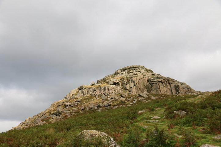
Near a small parking spot, the lane was coming to an end and so the only – indeed – the best option from here was to climb Sheepstor. It’s just a small mound by comparison to some of the other tors on Dartmoor and perhaps the biggest hazard is tripping over the numerous boulders of granite that have found their way down its slopes. Various routes worn by ramblers and sheep led up to the tor, and there was no single clear summit on which to gather; instead several plateaus of granite offered fine views in all directions: south, over the church and patchwork of white-dotted fields towards the haze of Plymouth and the sea; west across the reservoir and over towards the Tamar Valley and the uplands of Bodmin Moor; north to the shattered peaks of Leathertor, Sharpitor and Great Mis Tor beyond; and east to an open exposed landscape that could almost go on forever.

Routes from here could be multiple but I decided to descend from the tor back towards Burrator Reservoir. I could make out a track returning to the world’s narrowest road and the woodland around Sheepstor Dam Wall. Getting to this track took a little guesswork, but part of the fun of Dartmoor walking is making your own path along the clutter of the tors, descending with as little jumping or tentatively inching down on your arse as possible. Once off the rocks, the trails are easier to distinguish, lines of clarity carved out from the bracken and gorse.

And so, without grazing my arse I made it back down to the water level and retraced my steps from the lane, through the woodland, across both dam walls to the car. Except for one little detour; a Willy’s ice cream van parked up near Burrator Dam. Childhood memories and present day reappreciation amalgamated in one.
EXTRA STEPS
- The road around Burrator provides access to countless other ambles and longer hikes. At the northern end of the reservoir, Norsworthy Bridge often has an ice cream van in summer and walks can lead up to Down Tor and beyond. The road circuit also seems to be a popular cycling spot, though note water views are at a minimum as it mostly weaves through forest.
- If you fancy heartier refreshment than ice cream, the Burrator Inn in Dousland will offer the requisite ales, pies and other classic fare! A good cream tea option – and a delightful drive of about 10 minutes across the open moor from Dousland – can be found at the Fox Tor Café in Princetown.
- Watch out for sheep! After Dousland, the turn off to Burrator is frequently littered with sheep nonchalantly grazing and sleeping on the verge. They rarely move for cars.
- Buses from Plymouth may or may not make it to Burrator Dam, especially on weekends in the summer. Services are always changing, being taken over by different operators and subject to cancellation. So for up-to-date info Google it first!
LINKS
Dartmoor National Park site: https://www.visitdartmoor.co.uk/
Burrator Reservoir map: https://www.swlakestrust.org.uk/lakes/devon/burrator/#download-map
