into the north
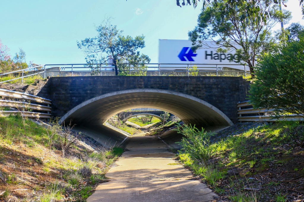
It comes as something of a surprise when a cyclist overtakes me in a tunnel underneath the road to Sydney. After the populous, touristed central sights and the activated suburban foothills, this little piece of the Canberra Centenary Trail is far from a showstopper. Other than in trucks and laybys I have barely seen a soul. Yet here this guy is, pedalling away to someplace or other. A destination. Some form of culmination.
As it turns out, his culmination today is just a little further up, beside a gate entering the generous expanse of Goorooyarroo Nature Reserve. The gate – while not unassailable for man and bike – provides that visible circuit breaker. We greet and chat and he tells me where he has come from and his pleasure at going back there, mostly because it will be downhill. Noticing my camera he asks if I am going shooting, and it takes me a few seconds to register that I am not off to cull kangaroo or embark on highway robbery. Both feel feasible on this part of the trail.
Bidding farewell and good day sport, this gate too is something of a borderline for me, though I don’t quite appreciate it at the time. It represents a westward shift, crossing what looks like a central axis bisecting Canberra. The same road that I have just passed under leads all the way down into the city and across the lake to Parliament House, onward through the Woden Valley to the deep south. Thus far I have always been walking to its east. Until now.
The most recent part of the journey has taken me into the north of the city, essentially traversing the twin reserves of Mount Ainslie and Mount Majura. They are both prominent hills, encircled by the bush. Indeed, at 888 metres, Mount Majura may even represent the highest point of the trail, though it is unclear at this point. The trip along the way has ticked off another twenty clicks or so (plus all those undocumented extras), slow and steady over several legs:
- Day 5: Mount Ainslie
- Day 6: Mount Majura
- Day 7: Majura North to the Parkway
- Day 8: Majura Parkway to Goorooyarroo South
Yet, however staggered, it feels like progress. To be this far north. And now crossing west, into a new destination, each step leading closer to some form of culmination.
Tuesday April 28: Peak Canberra
The vantage from the steps leading up to the Australian War Memorial is classic Canberra. Looking down Anzac Parade it is all angles and symmetry and meticulous planning, spreading arrow-straight across the lake to the house on the hill. In the immediate surroundings there seems no expense spared. No municipal neglect creeping into the immaculate arrangement of parade grounds and flower boxes. No underfunding of bronze and glass memorials placed at perfectly regular intervals along both sides of the road. The budget for war remembrance is seemingly infinite and unquestioning.
This is also a vantage, I realise, from where I can vaguely trace back how far I have walked on this journey along the Centenary Trail so far: to Parliament and then up to Red Hill, following that ridge south to Mount Mugga Mugga and – somewhere behind that – the pines of Isaacs Ridge. Back there it was early April and I was still in a T-shirt. Today, it is late April and the news is even better: I am still in a T-shirt along with shorts. At around 22 degrees I am perhaps the only one but a key determinant of this sartorial splendour is a deteriorating forecast of rain followed by single-digit tops in coming days. This feels like the last day for shorts possibilities.

My relative nakedness comes as a surprise to Alex, who again joins me for this leg of the walk and promptly returns his fleece to the car. It is a smart decision because we are set to climb up to the summit of Mount Ainslie, the principal paved pathway for puffing Canberrans smothered in activewear and plugged into damaging volumes of – as my stepdad so memorially put it once – ‘doof-doof’ music. Not everyone is a runner or brisk walker and not everyone is parading their bulging bits and pieces, but you do often feel in the inadequate minority.
I once succumbed, partially. There was a period where I determined to walk up Mount Ainslie as quickly as I possibly could. No running – for that just seems ridiculous – but certainly some pacey strides and rapid breathing. It turned out that I could summit in such conditions in about 20 minutes, so I then set about trying to break the 20 minute barrier before nibbling away at that time. My personal best was 19:14, an apt figure looking back down on that temple of wartime commemoration.
No such stupidity today and thus hopefully no feeling sick at the summit. The trail naturally climbs but when you are taking your time and taking in the surroundings it isn’t so tough. One of the blessings of this walk is the distinct stages as you progress. Two steep sections are interrupted by a more meandering, gentle path in between which allows for a generous natural breather. And at each transition the flora subtly alters; from roaming Eucalyptus grasslands around the bottom, then through tunnels of Drooping She Oak offering shade, before climbing again amongst flailing Scribbly Gum and Stringy Bark sprouting from the hill. At points there are glimpses of a view but it’s not really until you reach the final series of steps that the world opens up, happily resulting in regular breathers to take it all in. Unless you are aiming for 19 minutes and 14 seconds.
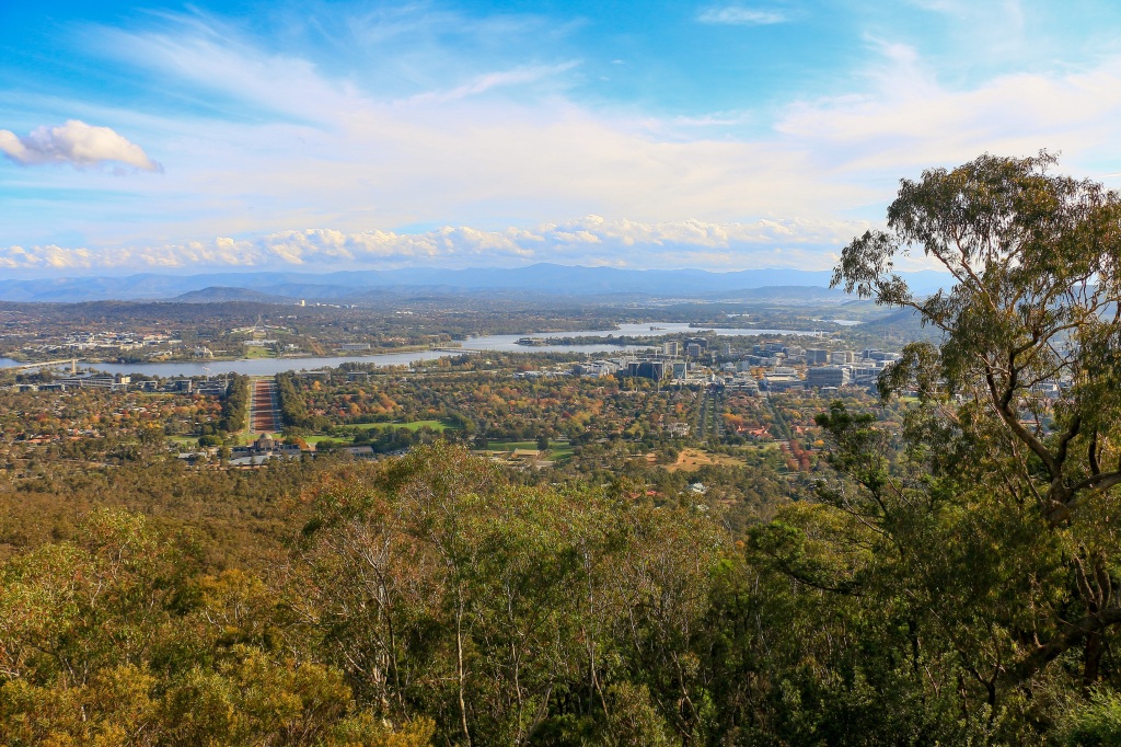
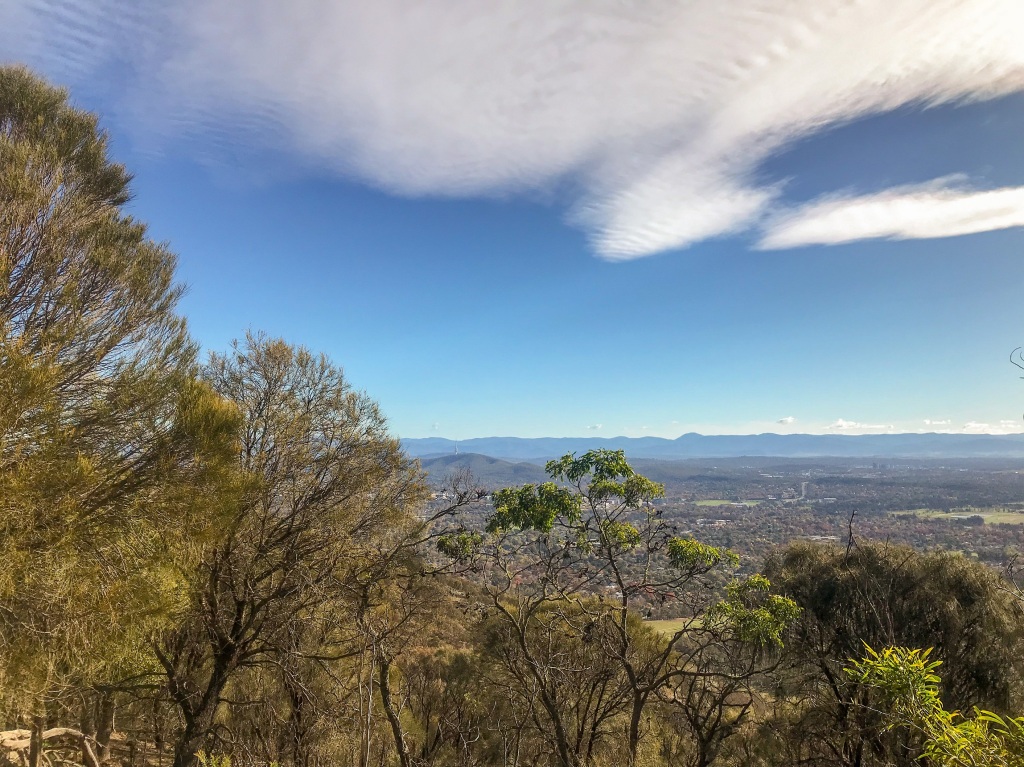
It had been a while and I had forgotten how comely the outlook was from the top of Mount Ainslie, particularly on such a day at such a time of year. The perspective is remarkably similar to that down by the War Memorial, yet it is a view considerably elevated by elevation. This perch higher in the sky affords quite wonderful views of the city of Canberra nestled in the bush, the reflective expanse of Lake Burley Griffin, the suburban ridges and folds along which much of the Centenary Trail runs. Canberra looks small from here and, in many places, hidden under the adornment of native and non-native trees lining its streets and circles. The planning is clear yet there is a licence for nature to roam. Looming, wild mountains to the south and west exacerbate the insignificance of the city yet also cradle it into the landscape as though a perfect fit.

I can easily now trace the route taken and, pivoting north, what is still to come. Mount Ainslie (843m) is but one summit to tackle going north, essentially linking up with the slightly higher and generally less frequented lump of Mount Majura (888m). The two peaks are buttressed by one continuous stretch of bushland reserve, to the extent that Canberra occasionally disappears and you could be forgiven for thinking you are somewhere even more off grid. This is not an infrequent occurrence walking in Canberra, a vanishing act which can be manna to its detractors or an absolute miracle to its fans. I tend to think it’s a miracle: to be in nature, to be surrounded by the bush, and only five minutes drive from the best coffee in Australia.
While nature often pervades, the intrusion of city essentials rears its sometimes ugly head as a stark reminder that fortunate people have got to live in first world comfort somewhere. I’m starting to realise the Canberra Centenary Trail – as it traverses the suburban fringe – frequently illustrates this juxtaposition. For instance, winding among the gums is a road up Mount Ainslie and a road means an opportunity for hoons to rev their sad excuse for a penis extension. West of Mount Majura, the cleared land and tightly packed shimmer of Gungahlin glistens in the sun. And, gently descending the back side from the summit through a bushland wonderland, the Centenary Trail emerges into the wide, straight dirt track of Pylon Avenue.

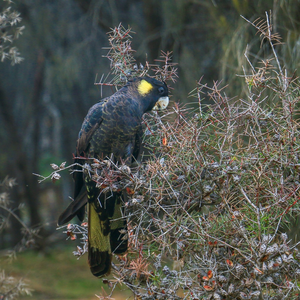
Even here, though, a little miracle resonates through the air. It’s not the crackle of high voltage electricity but the cries of a cluster of Black Cockatoos. I have heard these things on practically every stretch of walking so far, briefly spotting a pair with their yellow tails floating off high in the sky. But today they sit and meet and feast in a social gathering of ten or so. I have never seen so many at once, unperturbed by us humans passing distantly by. I wonder if they will continue to coax me along on this trip.
Thus Mount Ainslie delivers a little piece of natural wonderment again, twenty years following the first magical instance. Back then I had somehow made my way here without the guidance of any map as the winter daylight dwindled. I was due to head back to Sydney the next day and, passing the War Memorial, found this little track behind it heading into the bush. I strode quickly, hopeful for a view, wary of being media fodder as one of those Pommies who gets lost in the outback and survives on a pack of Extra Strong Mints. I pushed on at some pace – twenty years younger after all – perhaps unknowingly to set a record ascent. But I never made it because – at around the cluster of She Oaks – the darkness set in. 19:14 remains.
While far from disappointed I never really got a clear view out over Canberra. Heading back down in the twilight, thinking about what and where to find some dinner, I heard a rustle in the bushes. Bounding across the path a few metres in front of me, an Eastern Grey Kangaroo, followed by another and another and another. Being a wary alien in this deadly land it was prudent to watch and wait, rather than hope that they would stop for me. And, at that time, it was a pretty much pinch yourself kind of moment. My first visit to Australia, my first kangaroo in the wild, my first observation of their impressive mode of travel. And as the last red blushes sat in the sky over the Brindabellas, I felt charmed by this city, this bush capital. Power pylons and all.

the numbers
Trail section: Mt Ainslie up and down
Trail length walked: 5.3km
Total length walked: 9.1km
Total steps: 12,500
Altitude gain: 256m
Sunday May 3: Peaking Canberra

With Mount Ainslie ticked off, the next dominant feature along the Centenary Trail was the summit of Mount Majura. In truth, reaching here is actually a little extension and could technically be avoided all together. Indeed, I wasn’t really sure if I would bother with going all the way to the top or simply stick to the cycle-friendly route meandering along its base. In the balance of lethargy and motivation, my indecisiveness was having a field day.
To help delegate the vexation of me making a decision I put a little WhatsApp message out gauging interest for a loop walk up the mountain. If there were any bites, I would go along with it; if not an alternative cycle and walk combo along the flatlands might entice me outside. Or I could just stay at home in my COVID-loungewear.
The latter was never really an option, largely because this was the first sunny and calm day following two days of rain and two days of frigid, wind-chilled abomination. Having been sheltering indoors I would inevitably go out for a walk somewhere, so I may as well make it the Centenary Trail. This is the way my thinking is shaping at the moment – every kilometre at every opportunity counts. So when I received a couple of messages back expressing interest and alignment with plans, it was a done deal.
The initial part of this stretch ran behind the comfortable, gentrified suburbs of Ainslie and Hackett. This area epitomises an Inner North essence of sturdy brick and sheltered garden; while a touch grungy in places, perhaps even once – god forbid – working class, I imagine a cosiness, a warmth to these homes nestled under golden brown canopies. I can see myself on a Sunday afternoon such as this one sitting snugly reading a book, while dust motes hang in the air, reflecting the sun streaming in through wooden blinds. In such climes, I might just doze off.
One of the personal challenges of doing the trail at this time of year is the yearning to walk at the best (i.e. warmest) time of the day and my fondness for a nap. There is a serious conflict of interest, and it was nearing a soporific two o’clock in the afternoon as I mustered energy to begin the climb up Mount Majura from Hackett Gate. Being a Sunday afternoon on a fine, sunny day, I was not the only one. It seems the good people of Ainslie and Hackett like to get out and exercise, rather than curl up among dust motes nodding off with a book. Could I…well…Hackett?
Joining me along the trail, my friend Michael had, by coincidence, planned to walk up Mount Majura today anyway. It was part of an effort to climb some of Canberra’s prominent hills during our COVID climate. Not quite obsessive peak-bagging, but an aim to tick off a few summits nonetheless. It got me thinking about the concept of peak-bagging and another possible future endeavour that I have no doubt substantially achieved already anyway. There are so many hilltop reserves in Canberra it seems like you could go on forever. What would be the cut off? A named peak? A ‘hill’ or a ‘mount’? Seven hundred metres altitude? Places that can incorporate a coffee and cake? And then what about the bigger mountains west and south of the city? Some so high that they are shimmering snow-capped today.

Peak-bagging makes me think of Scotland and, more precisely, accumulating Monros. I think I bagged a Munro once on a walk with Dad. We had been staying in Scotland for a couple of weeks and had one whole day of sunshine during that period. We eventually gave up when our air mattresses ended up floating in the tent somewhere near the Cairngorms. The reason I am not one hundred percent certain of having bagged a Munro is that you couldn’t really see much. Call it gloam, cloud, mizzle, haar, fog and a wee drizzle and then multiply it by a thousand. We think we reached a summit, but then it could have been another mile up in the sky.
The contrast with today is like chalk and haggis. The famous Canberra blue sky is back and the snatched views of the snow-capped Brindabellas are impressive. Of course, I didn’t bother bringing my decent camera with me so I couldn’t grab a zoomed in oversaturated and heavily contrasted grainy image that might be snow. In truth, the day after the previous Ainslie walk I felt a bit crumby, all achy and old man like, and I wanted the liberation of being bag free to mitigate against any such repeat. Just a water bottle in my hand and a square of never-ending date loaf in my pocket. Didn’t Alanis sing about that once?
Unburdened, the walk up was very agreeable, embarking upon a series of switchbacks relatively gentle and passing through fairly dense, slightly stunted bush. At a plateau views to the airport reminded of the times, a parking lot of planes waiting for all this shit to be over. Nearby, Ikea was no doubt bustling, an essential outing for a Grbuhkollvengenskotthbul magazine rack always a popular Sunday pastime. Elsewhere, among the green fields bordering the Majura Parkway a newer landmark twinkling in the sun: hundreds and hundreds of hail-damaged cars waiting to be resold, recycled, or returned to the great carpark in the sky.

From the plateau there was a junction for the path we would take back down to Hackett. But first, the summit. Here, the trail becomes wider but rougher and the steep climb up fosters wariness of stumbling on the way down. Despite this, there’s a busy flow of people of all ages making their way up and down at regular intervals. Those in ascent wondering, like me, when this is going to end. It seems to drag on longer than one might expect and hope.
Once there, the summit offers a different perspective to that of Mount Ainslie – mainly because vegetation and Mount Ainslie itself is blocking much of the view over central Canberra. Instead, more of the airport and carport and the northern suburbs towards Belconnen. Through the odd gap in trees, the pinnacle tower of Black Mountain is visible, as are some of the ranges behind it. The older, inner north suburbs hide under bursts of red, yellow, and green while further distant the burgeoning, treeless sprawl of Gungahlin disappears into the rolling fields of New South Wales.
Closer to hand there is a road leading to the top of Mount Majura though this one is kept closed most of the time. I suppose it’s for the radar station that sits at the top, presumably guiding the hundreds of planes not in the sky. While this closure means the summit largely escapes the disturbing sight of clusters of sweaty MAMIL, it’s a shame you can’t really head back down that way because there is a winery and truffle farm beyond a locked gate. It would be a hefty detour, but after a few glasses you could somehow make your way back to Hackett in quite the merry fashion.
That’s not to say the conventional route back was anything less than merry. Accompanied by varieties of wallaby and kangaroo and the plethora of black and white birds making annoying noises that are – admittedly – less annoying than at six in the morning, it was a very fine bushwalk indeed. After navigating the steep descent from the summit without falling over, the path from the plateau cut along the side of the peak before winding slowly down through the bush to spill out onto the main lower trail. Back onto where I could have been all along. And where I would need to re-join, next time.
The loop on this detour was coming to a close, as we strode on along the wide, red earth trail to return to Hackett Gate. Yes, I could have clocked up more CCT kilometres (it’s become an acronym now) if I had ignored the summit. But it was a detour I would have regretted missing out on for sure. A very good decision indeed.

the numbers
Trail section: Hackett – Mt Majura Loop
Trail length walked: 6.0km
Total length walked: 8.8km
Total steps: 11,800
Altitude gain: 264m
Tuesday May 5: My Way or the Highway

The Federal Highway is usually an extremely popular road, leading as it does out of Canberra and on towards Sydney. Or Goulburn, the only place in the world where you can order a Big Mac in the shadow of a giant concrete Merino. It’s funny how our perspectives alter with circumstances: a day trip to Goulburn now sounds like something to look forward to.
Sticking entirely within the ACT, the next phase of the Canberra Centenary Trail is forced to navigate the Federal Highway as it transitions from the Majura-Ainslie Massif to the Goorooyarroo-Mulligans Outback. The transition is not the most straightforward, neither is it the most picturesque. Unless you really dig the braking sound of road trains and the sight of diesel plumes billowing into the air. The landscape of highway fringe offers that unique mix of surprisingly lush undergrowth ideal for discarding bodies, bits of obliterated truck and – somehow – random patches of concrete. Through it all, the reliable placement of markers for the Centenary Trail reassure you to push on, hoping for a promised land.
In negotiating the highway I decided to complete two relatively shorter loops which – to be fair – also encompassed some pleasant bushland at either end. This first stretch essentially finished off my time in Mount Majura Nature Reserve and pushed on to the joyous intersection of the Federal Highway with the Majura Parkway. To enable this loop I dusted off my bike to link the finish and the start. I thought it would be downhill all the way.

After a short but decidedly uneven pedal along the Federal Highway and through Watson, I locked up my bike in a busy, open parking area hoping that I would see it again. Re-joining the Centenary Trail required a further, steadily uphill walk of a kilometre or so, a non-trail trail that proved the nicest section of the day. Initial views from a sea of grassland exacerbated a prominence to Mount Majura marking it as significant and distinct. A small pond, glassy calm, offered reflection of the stately trees. Meandering upwards, the path crept through quiet, densely wooded forest.
Back on the track things were fairly pleasant too as I pivoted north once again. It was a journey typical of a traipse beneath a hill, regularly rolling up and down according to the contours formed by dry, shady gullies. At the apex of each rise views to the west were prominent and, most prominent of all, the communications tower atop Black Mountain. I would reach there one day, on this very trail, but for now it was emerging as an almost constant companion, reassuring like an old friend.
Commonly known as the Telstra Tower it provides a distinctive marker of place and – because it is plonked on top of a prominent hill – is more ubiquitous than other Canberra landmarks. The upturned needle is one of the last things you see in your rear view mirror on the way out of town and – consequently – one of the first things you see coming back. That initial glimpse on the horizon following a long journey is akin to the first sighting of the sea or the less impressive and thus totally incomparable Tour Eiffel. It sings out: welcome home.

The tower would temporarily disappear as the trail meandered slightly more inland, onto the north side of Mount Majura where the denseness of the bush thins out and a scrubbier mixed grass and low woodland dominates. It looks like the kind of landscape that has – at some point – been degraded by colonial efforts to eke out a living. Today it recovers, but in a haphazard and aesthetically underwhelming way.
One of the benefits of a thinned-out landscape is I get to witness a very rare sight indeed. I am informed by an information board that this is habitat for the vulnerable Glossy Black Cockatoo. Yet, however much I look, I do not see any of these. Instead, I hear something strange coming from the direction of the mountain: a loud, consistent thrum, like that of a jet engine. Suddenly overhead, a glistening white body appears in the deep blue sky, flecked with a red tail and two rigid wings. It pushes into the air, straight and ever upward. A Boeing 737, the unique 1430 COVID Express to Melbourne.
Rare airplane noise soon dissipates to be replaced by consistent noise from that Federal Highway. It seems forever close but frequently out of sight. Only until I see my own car, parked in a patch of gravel off the road, do I espy the spaced out rumblings of lorries heading north and south. It appears as though there are more lorries – transporting essentials like cement and oil and papier toilette – than cars.
I suppose while this is one of the most unappealing stretches of The Centenary Trail so far, in a perverse way I am lucky to encounter it in this weird period of our history. There are times when the dual carriageway is empty and it is only the sound of a truck engaging its engine breaks over the horizon at Eaglehawk which signifies something is on its way. Fewer vehicles seem to be escaping Canberra than entering which, again, encapsulates the unprecedented use of the word unprecedented in these unprecedented times.

Spurred on by this supposed good fortune I decide to extend today’s walk a little, really as a means to knock off more of the highway stretch and also to allow me an easier way to link up with the next leg. It’s essentially a quick there and back from my car to the Majura Parkway, taking in that wonderful fringe environment that borders a main road. It is surprisingly lush and bushy, there are scraps and remnants of rubbish, I am taking the occasional photo of vehicles and roadside crap to simultaneously bewilder and alarm motorists. Nearing the embankment above the parkway there are even a few bones decaying in rocky red gravel. Animals I assume but beware the lost and bewildered Englishman. The trail culminates in a cacophony of traffic lights and intersections negotiated by double axles and diesel-stained trailers. This is where I will restart next time, enticement if ever it was needed. For now, I turn around to trudge down the highway, the pointed beacon of Telstra Tower guiding me home once more.

the numbers
Trail section: Mt Majura North to Majura Parkway
Trail length walked: 4.7km
Total length walked: 7.0km
Total steps: 8,200
Altitude gain: 183m
Friday May 8: Life is a Highway. Still

Canberra is blessed with an extensive network of paved cycle paths. Some follow the main roads while others wander into those random tracts of empty space between suburbs, often aligning with the scenic storm drain network. All tend to be reasonably forgiving in gradient – any climbs are usually of the low percentage, grinding category more favourable to the slow diesel style of a 2011 Cadel Evans. A few shorter, sharper bursts may bring out the Peter Sagan in you, wheelies and all. Meanwhile, the odd coke can discarded on the side of the path hints at one or two Armstrongs in our midst.
Why am I harping on about bike paths in a mishmash of incoherence supposedly focused on the not particularly impressive feat of walking along the Canberra Centenary Trail? Well, today the bike path is my saviour, allowing me to link up with the start and finish of a grand Federal Highway finale. Having parked the car at the entrance to Goorooyarroo Nature Reserve, a bike path is the only thing stopping me from having to walk in the middle of the Majura Parkway to restart where I left off last time. Yes, the roads are quieter than usual, but not that quiet…especially when you take into account that this road leads to Costco, Bunnings and Ikea.
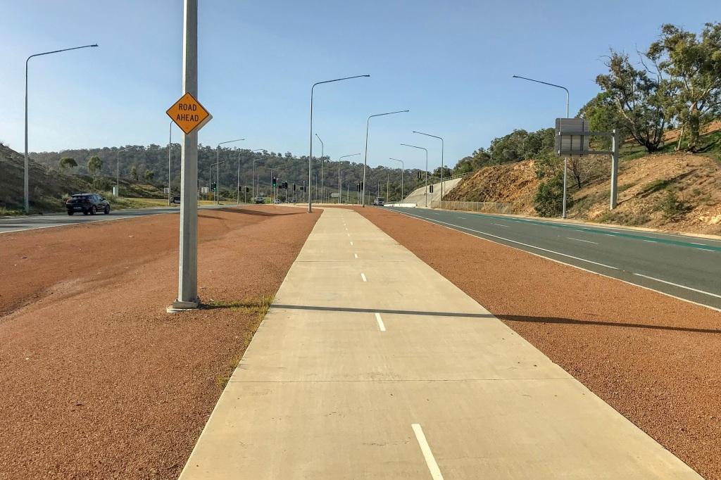
Thus the link walk was the antithesis of that on the last leg of my journey. Instead of grasslands and gums, mountains and ponds I had stop signs and concrete, streetlights and diesel. It was, however, mercifully short and – despite going uphill – climbed at a reasonably gentle gradient. Of course.
Reaching the Centenary Trail again there was some relief at being back on track though this was cloaked in doubt as to whether things would actually get any better. According to the map the trail had to negotiate a busy intersection, a parking area and a stretch of the Federal Highway, before crossing into the eastern edge of Goorooyarroo. A subway guided me under the first hazard and the path then followed what could only be described as the top of a motorway embankment. WRONG WAY GO BACK never seemed more pertinent.
While wedged between traffic noise and the sound of gunshots emanating from the nearby shooting range an incongruent picture of rustic charm presented itself: green fields, farm sheds, wily white eucalypts stretching out above a small dam. The parking area too was not without appeal, thanks to an array of native shrubs and several diverting plaques and wartime artefacts. These were gathered as part of the Remembrance Driveway scheme, which provides a series of rest areas, memorials, and tree plantings along the route between Canberra and Sydney. This one was the Hughie Edwards VC Memorial Park. Hughie, it turns out, was a Wing Commander in the RAF whose derring-do involved leading a high risk, low altitude daylight raid of the German port of Bremen during World War II. Born in Fremantle, he’s now remembered in a parking lot on the edge of Canberra.

It is a place where truckies inspect axles and take a long stretch, startled at the sight of a man walking upon the embankment with a camera around his shoulder. I feel like I have intruded upon a private moment of man and machine, interrupting an attempt to slope off for a few hours without the boss finding out. Doing my best attempt at a perfectly genial no worries kind of “howzitgahn” we briefly exchange acknowledgement of one another and move on, like trucks in the night.
Before long there is one more subway providing a milestone of sorts: finally crossing the Federal Highway. My expedition across the Majura-Ainslie massif has come to its end and I have now entered the fun to try and say Goorooyarroo Nature Reserve. This is an extensive swathe of rolling grassland and box gum bush which would keep me company for a while to come. Today, I was just nibbling away at its southeastern extremity, slowly but surely veering away from that highway.

Angling away from the road there came a point where it felt like the natural order of things had been restored. On the crest of a divide, a red dirt track led down through a line of eucalypts. A pair of Crimson Rosellas greeted me with their friendly chirrups, while through the trees a cluster of kangaroos grazed contentedly on the land. The highway noise had abated, the sky was blue, and a glimpse of the tower atop Black Mountain had returned to adorn the distant views. It was the perfect moment for a pause for water and the surprise bonus of a mini crème egg stowed away in my bag.

This reminded me of the recent SBS slow TV special – The Chocolate Factory: Inside Cadbury Australia. The unfortunate part of that title is the Australia bit; the difference between the British Cadbury and the Australian one being, in my view, pronounced. This is not to assert any arrogant superiority complex (well, maybe a bit), but the British one is far better. I don’t know why and can’t put my chocolate finger on it. A large part of it probably comes down to what you have grown up with, for I have offered British Cadbury to my colonial friends and they have been distinctly unimpressed. Apparently, they don’t like rich, creamy luxuriance and prefer untextured sugary disappointment. Anyway, in a sign that I have been worn down by circumstance, I am quite happy to eat Vegemite these days and was genuinely pleased to discover this Australian crème egg.
The sugary hit led me downhill towards the car. It had been a short, uneventful leg in which a very small artefact of chocolate was obviously a highlight requiring a whole paragraph to itself. Yet it was one of significance in making the transition across the highway, from one range of hills to the next system of grassland and bush. The borderlands await me.
Yet I cannot leave today, leave this section of the walk simply with another gate boasting a dispenser for hand sanitiser by a gravel clearing next to a main road leading to Costco and Ikea. What kind of a culmination is that after all? So, a short distance away, just off from the Centenary Trail, a pronounced hillock rises. This is Burnt Stump Hill (712m), imaginatively named because…well…you can guess.

Steeply rising through a grove of bird-filled pines, the summit is clear apart from that one stoic burnt trunk of a tree. The views over Canberra and beyond impress. To the left, the forested contours and cockatoo infested domain of Majura and Ainslie. In the centre, distant Black Mountain is backed by ever more impressive mountains beyond. And panning right, the ranges stretch north, spilling down into terrain to come. Around one hundred kilometres of it.

the numbers
Trail section: Majura Parkway – Goorooyarroo South
Trail length walked: 3.5km
Total length walked: 6.9km
Total steps: 7,750
Altitude gain: 129m

Love your descriptiveness of what are very familiar Canberra landmarks to us. I also have to say I am not a fan of Cadbury chocolate, UK or Australian….the difference being the additive needed to give the Australian version shelf life in our warmer climate. Love Goorooyarro Reserve, easy walking and full of wildlife.
LikeLiked by 1 person
Yes, nice to explore the Gungahlin side of the world for a change – some lovely open space and wildlife up there.
LikeLike
[…] think somewhere in my walking rambles during the midst of containment I made a sarcastic comment about the prospect of a day trip to […]
LikeLike